Atmospheric River #12 & 35
Forums:
I think I am going to write a so ng with that title. For my California brethren, today's installment is absolutely crazy here in Marin. Water coming down in sheets, I'm just waiting for the power to go out......be safe out there!
- Log in to post comments
Top of Page Bottom of Page PermalinkFull Name: Andy
Stay safe out there.
Stay safe out there.
Top of Page Bottom of Page PermalinkFull Name: treat island
Wow ~ be safe stay safe!
Wow ~ be safe stay safe!
Top of Page Bottom of Page PermalinkFull Name: (~)};)StealYourFace
Rainy Day, Dream Away...
Rainy Day, Dream Away...
Ain't no use in gettin' uptight
Just let it groove its own way
and a series of earthquakes to open the show
Top of Page Bottom of Page PermalinkFull Name: Druba
https://www.youtube.com/watch
https://www.youtube.com/watch?v=KU-kRsppY7k
Top of Page Bottom of Page PermalinkFull Name: Billy Shears
Well, they'll storm you when
Well, they'll storm you when you're tryin' to be so good
They'll storm you just like you knew they would
Top of Page Bottom of Page PermalinkFull Name: intentionally blank
> I think I am going to write
> I think I am going to write a song with that title.
Everybody must get soaked?
Top of Page Bottom of Page PermalinkFull Name: Woz
Bingo Mike!
Bingo Mike!
Top of Page Bottom of Page PermalinkFull Name: Def. High
Just gonna sit there and
Just gonna sit there and watch that river flow.
Top of Page Bottom of Page PermalinkFull Name: Lance minimum goad Newberry
Not so bad here in the south
Not so bad here in the south bay. Just a rainy day, no wind.
I really HATE those chilly winds.
Other than all the death & destruction, we've needed all this rain, but it's time for it to stop; we got baseball comin'.
Top of Page Bottom of Page PermalinkFull Name: Roarshock
No one knows for sure WHEN,
No one knows WHEN, or IF, the Atmospheric River Will strike again!
It will probably be on a Tuesday.
The Pineapple Express chugging along through the Banana Belt.
Beware the Bomb Cyclone!
Top of Page Bottom of Page PermalinkFull Name: El Nino
Just got flood insurance.
Just got flood insurance.
Top of Page Bottom of Page PermalinkFull Name: intentionally blank
We got some rain overnight
We got some rain overnight and about an inch of snow this morning. I'm not impressed.
Top of Page Bottom of Page PermalinkFull Name: Philzone Refugee
Atmospheric River take my
Atmospheric River take my hand...
Flood, reign o'er me...
Top of Page Bottom of Page PermalinkFull Name: Woz
We had bouts or rain, wind,
We had bouts or rain, wind, hail and sunshine since the sun rose this morning. Variety is the spice of life!
Top of Page Bottom of Page PermalinkFull Name: Thumbkinetic
Everybody must [glub]
Everybody must [glub]
Top of Page Bottom of Page PermalinkFull Name: An organ grinder’s tune
warm and sunny beautiful
warm and sunny beautiful spring day here yesterday. grey and raining today. hawaii sounding good right now.
Top of Page Bottom of Page PermalinkFull Name: El Nino
Tulare Lake is coming back.
Tulare Lake is coming back. You can see it here:
https://social.paulkedrosky.com/@paul/110107730849907422
Before it was drained for agricultural use the Tulare Lake covered up to 1,000 square miles. That's 640,000 acres. If flooded to just 10 feet that would be 6.4 million acre feet of water. In some places the lake is 20 to 30 feet below the perimeter elevation.
For comparison Lake Shasta reservoir is 4.5M acre feet, Lake Oroville is 3.5M acre feet and California's entire Colorado River allowance is 4.4M acre feet per year.
https://mastodon.social/@enmodo/110102331776380044
Top of Page Bottom of Page PermalinkFull Name: Mice elf
https://m.youtube.com/watch?v
https://m.youtube.com/watch?v=gKNkafzuI-Y
Top of Page Bottom of Page PermalinkFull Name: r n
How is Lake Shasta doing ?
How is Lake Shasta doing ?
Was way way, way down.
Top of Page Bottom of Page PermalinkFull Name: El Nino
Reservoirs are doing great.
Reservoirs are doing great. We have stored all we can store.
https://cdec.water.ca.gov/resapp/RescondMain
Top of Page Bottom of Page PermalinkFull Name: intentionally blank
That's good news for surface
That's good news for surface water in CA, but groundwater still has a ways to go.
https://sgma.water.ca.gov/CalGWLive/#groundwater
Top of Page Bottom of Page PermalinkFull Name: El Nino
Sacramento actually has an
Sacramento actually has an active program to recharge ground water which is pretty good. My tap water is all ground water except when there is a ton of extra water then we switch to Folsom Lake water. You can immediately tell the difference. The lake water is so low in minerals because it is almost all pure snow melt. It caused a bunch of houses in Folsom that use it all the time to spring leaks in their plumbing because the water district didn't adjust the ph and it ate through the copper.
Top of Page Bottom of Page PermalinkFull Name: Mice elf
https://www.nbcnews.com
https://www.nbcnews.com/science/environment/long-dormant-lake-reappeared...
Top of Page Bottom of Page PermalinkFull Name: MarkD
Big Ag takes it in the ass.
Big Ag takes it in the ass. Been following this a bit since I grew up in Fresno. That article says food but I am pretty sure most of that land was drained to grow cotton.
Top of Page Bottom of Page PermalinkFull Name: treat island
Thanks for article, Bss.
Thanks for article, Bss. It was interesting.
Top of Page Bottom of Page PermalinkFull Name: El Nino
It's interesting that climate
It's interesting that climate change means we ping pong through super wet and super dry winters but so far it hasn't affected the mean at all. We are still getting the same amount of water as we always have.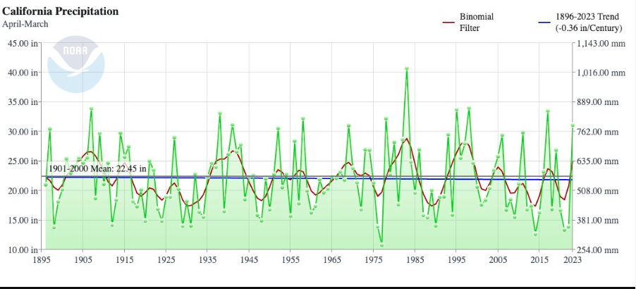
Top of Page Bottom of Page PermalinkFull Name: intentionally blank
> We are still getting the
> We are still getting the same amount of water as we always have.
That's really interesting to me because California is a huge state made up of many, very different local climates. What that graphic then suggests to me is that it's not how much rain CA gets (because it's always the same), but rather where it rains and when, and one place's loss necessitates another place's gain. Rain in CA is a zero-sum game, in other words.
Top of Page Bottom of Page PermalinkFull Name: Druba
it's not like there's more
it's not like there's more ocean / less ocean than before... the distribution pattern change is part of what we're learning about the man made chemical changes of our atmosphere
Top of Page Bottom of Page PermalinkFull Name: intentionally blank
> it's not like there's more
> it's not like there's more ocean / less ocean than before...
Tell that to the melting polar ice caps.
But I hear you about the distribution pattern thingy. Today was the first time I really glimpsed that on a local level.
Top of Page Bottom of Page PermalinkFull Name: Druba
During the ice ages, the
During the ice ages, the oceans were up to 90' below where they are today, many shelf break offs occured during those eras, originally thought to be earthquake tsunamis, but was more complicated than that. But that graph is a hundred some odd years, not tens of thousands, so it's not like all that oceanic water was locked up in the 50's or something, lol. But this is a La Nina year (or southern oscillation), so getting a wet late winter is party of that pattern.
Top of Page Bottom of Page PermalinkFull Name: Def. High
Some data suggesting a return
Some data suggesting a return to El Nino conditions later this year.
Top of Page Bottom of Page PermalinkFull Name: Woz
If that happens and we have
If that happens and we have another heavy rain season these predictions of central California flooding will become very true......Sacramento will be under water.....
Top of Page Bottom of Page PermalinkFull Name: El Nino
El Nino is coming:
El Nino is coming:
At this moment in time, no person alive has ever experienced global ocean temperatures as warm as they are today (i.e., the global average SST anomaly has reached record levels in recent days). This is despite remarkably cool patches of water in two regions: the sub-Antarctic eastern Pacific west of South America, and the mid-latitude East Pacific along the coast of western North America (including along the California coast). Nearly everywhere else on Earth, the oceans are presently much warmer than the long-term average–and this is especially true near the west coast of tropical South America near Peru, where SST anomalies are locally in excess of 5C (9F). That is an extraordinary level of oceanic warmth, and is highly suggestive of the early stages of a significant El Niño event.
And indeed: all other indicators also point to a rapidly-developing El Niño in the tropical Pacific. Westerly wind bursts are underway; subsurface warm water is sloshing eastward; and both dynamical models and statistical predictions suggest a very high likelihood of transitioning into El Niño conditions by this summer or autumn at the latest. In fact, dynamical model predictions continue to become more and more aggressive regarding the potential magnitude of the coming El Niño event–with some indicating at least some possibility of a “super El Niño” by next autumn (i.e., one comparable to or greater than the top-tier events that occurred in 82-83, 97-98, and 15-16).
You have to scroll down to get to the El Nino part
https://weatherwest.com/archives/25610
Top of Page Bottom of Page PermalinkFull Name: r n
My kid just drove past Lake
My kid just drove past Lake Shasta and sent a photo; the thing looks completely full.
Mt. Shasta has snow all the way down.
Top of Page Bottom of Page PermalinkFull Name: GDTRFB
"Study warns critical ocean
"Study warns critical ocean current is nearing 'collapse.' That would be a global disaster."
https://www.yahoo.com/news/study-warns-critical-ocean-current-215001730....
Top of Page Bottom of Page PermalinkFull Name: Druba
Greenland's glaciers melting
Greenland's glaciers melting cause a significant discharge of fresh water into the ocean (normally tied up in the ice). This water is much less dense than salt water, so the theory is that if enough fresh water is discharged, it can force the gulf stream to go deep, eliminating that source of heat that keeps Ireland from being Scandinavia... My prof from OSU went on to be a leading modeler of the Greenland Ice sheet / oceanic interactions (Michael Schlesinger, RIP).
Top of Page Bottom of Page PermalinkFull Name: Def. High
Currently 33 deg. and snowing
Currently 33 deg. and snowing at our place.
Thought it was Spring.
Top of Page Bottom of Page PermalinkFull Name: El Nino
Meanwhile in Fort Lauderdale
Meanwhile in Fort Lauderdale 22 inches in 7 hours
Downtown completely under water
https://twitter.com/douglasthron777
Top of Page Bottom of Page PermalinkFull Name: GDTRFB
What to expect during the
What to expect during the potential 'super El Niño'
https://www.yahoo.com/news/expect-during-potential-super-el-092508386.html
Top of Page Bottom of Page PermalinkFull Name: An organ grinder’s tune
if anyone really loves
if anyone really loves weather and nerding out, stormsurf.com is awesome and also produce a 45min super nerd cast weekly.
get your mjo's and heady oscillations here: https://www.youtube.com/watch?v=a2la3F3l5c4
Top of Page Bottom of Page PermalinkFull Name: Def. High
Snowing here again.
Snowing here again.
Top of Page Bottom of Page PermalinkFull Name: Def. High
Snow ing here again.
Snowing here AGAIN.

Top of Page Bottom of Page PermalinkFull Name: treat island
Today cold, rain and snow. 8
Today cold, rain and snow. 8 minute drive got pelted by ice, rain and snow. And then it was just rain. Lots and lots of rain.
Top of Page Bottom of Page PermalinkFull Name: Def. High
Forecast is for 80 deg. here
Forecast is for 80 deg. here on Fri.
Quite the turnaround.
Top of Page Bottom of Page PermalinkFull Name: El Nino
Wow 104 in Spain in April
Wow 104 in Spain in April
https://news.sky.com/story/spain-braced-for-record-breaking-april-temper...
Top of Page Bottom of Page PermalinkFull Name: Mice elf
Everything's bigger in Texas?
Everything's bigger in Texas?
https://www.washingtonpost.com/weather/2023/04/27/large-hail-texas-flori...
"grapefruit sized hail" might've made a good guy clark song
Top of Page Bottom of Page PermalinkFull Name: (~)};)StealYourFace
Yosemite Closed:
Yosemite Closed:
https://www.npr.org/2023/04/26/1172109520/yosemite-national-park-closed-...
Watching the River (over)Flow...
Top of Page Bottom of Page PermalinkFull Name: MarkD
That link should have
That link should have featured pics.
Top of Page Bottom of Page PermalinkFull Name: intentionally blank
It sounds like the flooding
It sounds like the flooding hasn't started yet, Mark. Here's the Merced on Tuesday. Click on the pic for full resolution.
https://www.washingtonpost.com/weather/2023/04/26/yosemite-closing-flood...
Top of Page Bottom of Page PermalinkFull Name: MarkD
Wow. Wish I was there.
Wow. Wish I was there.
Been in the 90's last few days here. Cooling down to the 50's with some rain over the next week. Weird.
Top of Page Bottom of Page PermalinkFull Name: intentionally blank
There's some more recent pics
There's some more recent pics here, but it doesn't look too crazy so far.
https://www.fresnobee.com/news/california/yosemite/article274837956.html
Top of Page Bottom of Page PermalinkFull Name: Druba
We set a bunch of record high
We set a bunch of record high temps around the great PNW yesterday... i'm hoping for thunderstorms next week.
(going to "Paranormal Cirque" at the Benton Co fairgrounds on Monday, a rated R horror circus, should be hot!)
Top of Page Bottom of Page PermalinkFull Name: Def. High
>>>>>should be hot!
>>>>>should be hot!
Yeah, those black tents.
Good thing the 90 deg. temps are done for now.
Top of Page Bottom of Page PermalinkFull Name: intentionally blank
The forecast is for cold rain
The forecast is for cold rain and snow later today where I'm at.
Top of Page Bottom of Page PermalinkFull Name: El Nino
Looking like we are headed
Looking like we are headed for a very strong El Nino next year. Index (central equatorial Pacific) has reached +0.6˚C for the first time this year. At this time in 1997, it was +0.30˚C & +0.22˚C in 1982.
If I remember correctly in SF we had something like 40 days straight of rain in 97
https://twitter.com/BenNollWeather/status/1658498302613045254?s=20
Top of Page Bottom of Page PermalinkFull Name: Woz
Yup, 1997 was an incredibly
Yup, 1997 was an incredibly wet winter in the Bay area
Top of Page Bottom of Page PermalinkFull Name: An organ grinder’s tune
my guy is calling for massive
my guy is calling for massive el nino.
Top of Page Bottom of Page PermalinkFull Name: El Nino
Guam is about to have a bad
Guam is about to have a bad 48 hours.
https://edition.cnn.com/2023/05/23/weather/typhoon-mawar-guam-forecast-t...
Top of Page Bottom of Page PermalinkFull Name: Woz
It's going to be a gnarly
It's going to be a gnarly weather year
Top of Page Bottom of Page PermalinkFull Name: El Nino
Wow just picking up parked
Wow just picking up parked trucks and rolling them
https://twitter.com/gingercruz/status/1661322627175297024?cxt=HHwWgMDRoZ...