Mt. Kilauea may be about to erupt!
Forums:
So, not sure if any of y'all have been following this, but Mt. Kilauea on the Big Island of Hawaii is having a funky tummy attack and citizens are being warned to prepare to evacuate from a potential eruption.
Some details: In April the lake of magma at the top rose really high and got within six meters of the top. More recently, the primary vent where lava has been oozing for about a decade rumbled and exploded and now where there was a pool of lave, the lave has all drained out. It has to go somewhere and they are tracking it underground. Two days ago there were 250 earthquakes in a 24 hours period in the lower Puna area of the island. That's SW of Hilo and S of Pahoa. Authorities are warning people to expect eruptions in a subdivision called Leilani Estates or near Kapoho. Yesterday the road in Leilani Estates started cracking, but so far nothing coming out of it. Much of Volcano National Park is closed and everybody is sitting around waiting to see what happens.
http://www.bigislandvideonews.com/2018/05/02/video-new-flyover-reveals-d...
This is fascinating stuff to watch and I can only imagine how freaky it must to be walking around knowing that there is a bunch of magma rolling around the upside down waiting to explode and spooge all over your house. In addition, road access in this area is very limited, so anything that fucks with the road strands these folks.
Anyway, I haven't seen much of this on the news so thought I would share it. Very eerie. Be safe, islanders.
- Log in to post comments
Top of Page Bottom of Page PermalinkFull Name: Alias
Sorry for the dubbel, missed
Sorry for the dubbel, missed my edit window.
Top of Page Bottom of Page PermalinkFull Name: Johnny D
WOW! Thanks for sharing this
WOW! Thanks for sharing this. We visited the volcano last year and it was quite the spectacle back then.
Top of Page Bottom of Page PermalinkFull Name: |-|/-\|_|_
I blame Dr Evil.
I blame Dr Evil.
Alias, did you guys already book a vacation there?
Top of Page Bottom of Page PermalinkFull Name: Alias
Yup googly. 4 days in Kona,
Yup googly. 4 days in Kona, 4 in Puna, right about where the earth may soon open to reveal the gates of hell. Hope not!
Really looking forward to this little safari.
Top of Page Bottom of Page PermalinkFull Name: |-|/-\|_|_
oh shit... can you maybe
oh shit... can you maybe switch the Puna accommodations to someplace that's still close, but that has more exit routes (like Hilo)?
Top of Page Bottom of Page PermalinkFull Name: Philzone Refugee
The Vog was thick that day,
The Vog was thick that day, my friends.
Top of Page Bottom of Page PermalinkFull Name: Alias
Non-refundable airbnb, yo.
Non-refundable airbnb, yo. But its far enough out that either it will be inaccessible and then we get a refund, or else things will have settled. Love the place we are renting, right on the water so even if access is limited we can take supplies and chill. But it has led me to take a pretty active interest in this volcano thing, for which I am grateful because I've never really pondered this reality much.
Top of Page Bottom of Page PermalinkFull Name: CT
Not to be an anti
Not to be an anti-sensationalist,
but Kīlauea has been continually erupting since the 80’s.
Top of Page Bottom of Page PermalinkFull Name: Johnny D
(((The Vog was thick that day
(((The Vog was thick that day, my friends.)))
Seemed to blow toward the Kona side when we were there. Glad we stayed in the Hilo area, for many reasons
Top of Page Bottom of Page PermalinkFull Name: Alias
>>>Kīlauea has been
>>>Kīlauea has been continually erupting since the 80’s.
OK, change it to "may be erupting in a populated area". From what I have read, each new spew from a new location and the flow that follows is colloquially referred to as an eruption. This is the official emergency statement from a couple days ago: “Due to this activity Hawaiian Volcanoes Observatory indicates an eruption is possible,” emergency officials say. “Because it is not possible to predict where an eruption could occur, the areas that could be affected are Nanawale Estates, Leilani Estates or Kapoho.”
Maybe you can call them up and correct them?
Top of Page Bottom of Page PermalinkFull Name: Racketinmyhead
Cool!
Cool!
Top of Page Bottom of Page PermalinkFull Name: Martinb
www.hawaiinewsnow.com
www.hawaiinewsnow.com/category/198303/livestream
Top of Page Bottom of Page PermalinkFull Name: Martinb
`Rift eruption in Leilani
^Rift eruption in Leilani Estates, emergency evacuations underway.
Top of Page Bottom of Page PermalinkFull Name: Druba
From Hawai'i Volcanoes
From Hawai'i Volcanoes National Park Facebook page;
Due to persistently unstable volcanic activity and the possibility of a new eruption, park officials temporarily closed Nāulu Trail, parts of Nāpau Trail and adjacent wilderness in Kīlauea Volcano’s East Rift Zone for public safety today.
A 5.0-magnitude earthquake around 10:30 Thursday morning triggered a small collapse at Pu‘u Ō‘ō vent that sent a rose-colored plume billowing skyward, and deposited ash downwind. Earlier, the lava lake within Halema‘uma‘u Crater at the volcano’s summit dropped about 100 feet or more below the vent rim. Lava is no longer visible within Halema‘uma‘u.
“Today’s activity further supports the continued instability in the East Rift Zone,” said Park Superintendent Cindy Orlando. “Safety of visitors and staff is our highest priority,” she said.
Approximately 31,660 acres (9.5 percent) of the 333,308-acre park are closed. Most of the park remains open, including Jaggar Museum, Nāhuku (Thurston Lava Tube), Mauna Loa Road and much more.
On Wednesday, park officials extended the closure of the Pu‘u ‘Ō‘ō cone to the ocean, closing the gravel emergency access road from the eastern gate near Kalapana, to the western gate at the end of Chain of Craters Road, and all land on the makai (ocean) side of the emergency road.
On April 30, the crater within Pu‘u ‘Ō‘ō collapsed, and a swarm of low-magnitude earthquakes continue to rattle communities in lower Puna. Scientists at the U.S. Geological Survey Hawaiian Volcano Observatory report that an intrusion of magma is heading eastward from the vent towards Highway 130.
Puna residents are encouraged to sign up for Hawai‘i County Civil Defense messages at http://www.hawaiicounty.gov/active-alerts/, and to subscribe to volcanic updates via USGS: https://volcanoes.usgs.gov/vns2/.
Top of Page Bottom of Page PermalinkFull Name: Druba
Kilauea eruption sends
Kilauea eruption sends fountains of lava into air; evacuations ordered
Updated; Thursday, May 3rd 2018, 11:47 pm PDT
PUNA, BIG ISLAND (HawaiiNewsNow) -
Authorities have ordered mandatory evacuations in Leilani Estates, where lava is cutting through the community, spewing more than 100 feet in the air and nearing several homes.
Geologists say Puna quakes similar to events leading to 1955 eruption
Hawaii County Civil Defense is urging residents in the Puna community, home to about 1,700 residents, to get out now and has sounded warning sirens. Two emergency shelters have been opened — one at Pahoa Community Center and the Keaau Community Center.
Meanwhile, Gov. David Ige has activated the Hawaii National Guard "to help with the evacuations as well as the security of that community." And U.S. Sen. Brian Schatz, D-Hawaii, said FEMA is also mobilizing resources for Hawaii Island.
He urged Big Islands residents to "stay calm" and continue to stay tuned to emergency alerts.
Those residents are fleeing with few belongings — just what they could grab in the minutes they had to leave. One resident said he grabbed his father's ashes as he ran out the door.
"My family is safe, the rest of the stuff can be replaced," another resident said. "When I bought here 14 years, I knew that this day would eventually come. But the reality is sinking in now."
He added that he was "100 percent sure" that there are going to be structures destroyed by morning.
Residents and social media posts show video of lava spewing through a long fissure cutting through the community, and a dramatic drone video shows the lava flow extending for several hundred yards, spatter bubbling up from roadways and forest.
Resident Ikaika Marzo said he could also see "fountains" of lava in the community topping 100 to 125 feet.
The lava outbreak was first reported about 4:30 p.m., some six hours after a 5.0-magnitude earthquake shook the Big Island Thursday morning. That quake came after hundreds of small tremors rattled the island since last week.
The Hawaiian Volcano Observatory said the larger quake Thursday caused rockfalls and possibly an additional collapse into the Puu O'o crater, not no immediate eruption. The plume dissipated as it drifted southwest, dropping ash on some nearby communities.
The quake happened around 10:30 a.m., and was centered in the south flank of Kilauea volcano at a depth of 6.9 kilometers, the USGS said. It was originally reported as a 4.6-magnitude tremor, but its strength was later increased.
Residents from Puna to Hilo said they felt the temblor, the biggest in recent days to hit Hawaii Island, which has been rattled with hundreds of small earthquakes since last week. The larger quake was followed up by several smaller tremors ranging in magnitude from 2.5 to 2.8.
Earlier Thursday, seismic activity had flagged — a good sign — but officials continued to stress that residents along Kilauea's east rift zone should continue to prepare for a possible eruption.
The first signs of trouble in Leilani Estates came about 4:30 p.m. Thursday, when residents reported plumes of smoke spewing from cracks in the road.
On Wednesday, cracks were also reported on the road in Leilani Estates, but officials reported they did not pose a lava threat.
Still, the cracks added to residents' anxieties as the quakes didn't let up.
"Last night, we started having them ... about five a minute. It was like that just about all night long," said Chris Burmeister, who lives in Leilani Estates. "It'll rumble for a little bit. Rumble for a little bit. And then every now and then, you'll get just a heavy jolt."
According to the U.S. Geological Survey, there were nearly 70 earthquakes of magnitude 2.5 or stronger from Tuesday to Wednesday.
Amid the quakes, scientists installed additional GPS monitoring equipment and deployed crews to put in even more monitoring tools.
Top of Page Bottom of Page PermalinkFull Name: _________
https://www.nbcnews.com/news
https://www.nbcnews.com/news/us-news/volcanic-eruption-sparks-mandatory-...
Top of Page Bottom of Page PermalinkFull Name: Alias
Got to say, from what I have
Got to say, from what I have seen everyone who lives there is pretty chill about it. I guess you do that when you know you live on a volcano. Hope damage is kept to a minimum though.
Top of Page Bottom of Page PermalinkFull Name: Alias
(No subject)
Top of Page Bottom of Page PermalinkFull Name: CT
Leilani estates, at Pohoiki
Leilani estates, at Pohoiki road.
will be sad if it keeps flowing for months or years, and much of lower
puna ends up under lava..
thats a beautiful unique area down there
Top of Page Bottom of Page PermalinkFull Name: Alias
Three separate vents are open
Three separate vents are open now, this seems really bad.
Top of Page Bottom of Page PermalinkFull Name: Druba
Keeps ramping up;
Keeps ramping up;
Top of Page Bottom of Page PermalinkFull Name: Druba
They just had a large
They just had a large earthquake (was 5.6 initially, now 5.3), with multiple aftershocks in the 3. - 4. range. Sounds like multiple eruptions along the rift;
Top of Page Bottom of Page PermalinkFull Name: Druba
That Earthquake has been
That Earthquake has been upgraded to a 6.9!!!
Here's an earlier earthquake map; (color coded for depth, with purple being the most shallow)
Top of Page Bottom of Page PermalinkFull Name: _________
^^^^ WHAT !________ Mt.
^^^^ WHAT !________ Mt. Kilauea = Gnarly !!
Top of Page Bottom of Page PermalinkFull Name: _________
https://www.cnn.com/us/live
https://www.cnn.com/us/live-news/hawaii-kilauea-volcano-eruption/
Top of Page Bottom of Page PermalinkFull Name: Highnote
My daughter is in Hilo. She's
My daughter is in Hilo. She's getting rocked 20 miles from the rift zone.
Top of Page Bottom of Page PermalinkFull Name: Druba
(No subject)
Top of Page Bottom of Page PermalinkFull Name: MarkD
looks like Kapoho might be
Looks like Kapoho might be spared. Some of the best snorkeling on the island.
Top of Page Bottom of Page PermalinkFull Name: Druba
(No subject)
Top of Page Bottom of Page PermalinkFull Name: Druba
Top of Page Bottom of Page PermalinkFull Name: Druba
(No subject)
Top of Page Bottom of Page PermalinkFull Name: Druba
(No subject)
Top of Page Bottom of Page PermalinkFull Name: Druba
(No subject)
Top of Page Bottom of Page PermalinkFull Name: hooper
^^^ Yikes!
^^^
Yikes!
Top of Page Bottom of Page PermalinkFull Name: Druba
(No subject)
Top of Page Bottom of Page PermalinkFull Name: Druba
(No subject)
Top of Page Bottom of Page PermalinkFull Name: Druba
(No subject)
Top of Page Bottom of Page PermalinkFull Name: Druba
(No subject)
Top of Page Bottom of Page PermalinkFull Name: Philzone Refugee
It's pretty humbling to realize the core of the planet we call home is liquid fire.
Looks like Hawai'i Volcanoes National Park is partially open. There's some video taken at the crater 2 weeks ago here showing a lot more activity than when I visited two years ago:
https://www.nps.gov/havo/index.htm
This is the current info on the park:
Hawaii National Park, Hawai‘i – Hawai‘i Volcanoes National Park reopened Sunday at 3 p.m. following a sequence of large, violent earthquakes that prompted a two-day closure and evacuation of park visitors and staff last Friday.
“Our primary objective is the safety of employees, park partners and visitors,” said Park Superintendent Cindy Orlando. “The limited opening allows us to respond to new volcanic and seismic events should they occur and the closures that remain are necessary to keep people out of dangerous and unassessed areas. Visitors should expect changing conditions and be prepared for unannounced closures,” she said.
Park staff are busy assessing trails, roads and buildings in the park, and thus far, minimal damage has been reported. However, several rock slides were triggered by the 6.9-magnitude earthquake that struck Friday at 12:32 p.m. and a slew of aftershocks and smaller earthquakes that preceded it. The USGS reported 500 earthquakes have occurred in and around Kīlauea Volcano since Friday afternoon, and smaller temblors continue today.
The following areas are open:
The Entrance Station from Highway 11 to Jaggar Museum is open from 3 p.m. to 10 p.m.; Jaggar Museum will close at 8 p.m. (the outdoor overlook will remain open until 10 p.m.)
Kīlauea Visitor Center is open from 3 p.m. to 8 p.m.
Sulphur Banks Trail
Steam Vents parking lot
Crater Rim Trail is open from Kīlauea Overlook to Jaggar Museum only
The Entrance Station to the 1969 lava flow near Mauna Ulu
Mauna Ulu to Pu‘uhuluhulu (Nāpau Trail is closed past Pu‘uhuluhulu)
Escape Road from Highway 11 to Mauna Ulu
Mauna Loa Road from Highway 11 to the Mauna Loa Lookout and Kīpukapuaulu
Any area in the park not listed here is closed, including most trails, Nāhuku (Thurston Lava Tube), Kīlauea Iki, Devastation Trail and Pu‘u Pua‘i and Chain of Craters Road past Mauna Ulu.
Due to the hazardous and unpredictable ash plume coming from Pu‘u ‘Ō‘ō vent, there is a Temporary Flight Restriction (TFR) above the vent. Aircraft (including drones) are not permitted in the TFR, which extends 3,000 feet above ground level and a two-mile radius from the vent. Relief aircraft on official flights approved by the National Park Service are the only aircraft allowed in the area.
-NPS-
Top of Page Bottom of Page PermalinkFull Name: Druba
This stoner's using the lava
This stoner's using the lava for toking...
https://www.facebook.com/dabstars/videos/818996971618533/?hc_ref=ARSTnms...
Top of Page Bottom of Page PermalinkFull Name: Druba
2 new eruptions with
2 new eruptions with evacuations in In Lanipuna Gardens;
Top of Page Bottom of Page PermalinkFull Name: Alias
Was bummed to see two more
Was bummed to see two more vents, it seemed like maybe those folks would get a day off.
Top of Page Bottom of Page PermalinkFull Name: Druba
A dear friend lives 3 miles
A dear friend lives 3 miles from there, lots of sharing of videos and jokes on Facebook. Been posting all the videos on my FB mining page (Husky Hiker Mining), getting a pretty good collection sadly... So far it's been a real classic fissure on a rift. Was hoping things would settle down when the lake of lava drained out, but todays activity was concerning! Not only because of the new spots, but because some of the old ones re-erupted, and that hasn't happened yet. That 6.9 earthquake was between the fissure and the Puu Oo lava pool, and only 2.1 km in depth (shallow), likely responsible for the lava shift... now if that entire source for the volcano switches to the fissure, that could be very ugly. I'm just hoping the PBS / DSC / etc gloom and doom doesn't happen, where that entire part of the island slides off, creating a pacific tsunami, let alone when the ocean meets the underground lava pool.
Top of Page Bottom of Page PermalinkFull Name: Druba
Fissures, Earthquakes, and a
Fissures, Earthquakes, and a possible new area (fresh cracks in the roads) from the last 24 hours
Top of Page Bottom of Page PermalinkFull Name: treat island
Thanks, Noodler.
Thanks for the depictions, Noodler.
Top of Page Bottom of Page PermalinkFull Name: Druba
I've been pitching in on some
I've been pitching in on some of the facebook groups devoted to that area, saw video the drummer friend of my buddy put out when the lava first started, freaking nuts! Have met online a few folks right in the thick of it, including a worried lady whose home is right where the new cracks are on Ala ili right (where the orange circle above is).
Here's my buddy and I jamming on guitars at the Oregon Country fair back around 90/91, much better times!
Top of Page Bottom of Page PermalinkFull Name: Druba
https://www.google.com/maps/d
https://www.google.com/maps/d/viewer?mid=1CvBhH9wEeztBrqYbsGDi4YjU1k1QH5...
Top of Page Bottom of Page PermalinkFull Name: VivalaSchwa
Thanks, Druba. You may be
Thanks, Druba. You may be inline for a Vivalitzer Prize for your reporting on this. Seriously great, although devastating, information.
Top of Page Bottom of Page PermalinkFull Name: Druba
Lol, well, always been a
Lol, well, always been a science nerd... and geology (lode mining) is my late mid life crisis of choice (since injuries / health ended my last career). I've gotten involved with several FB groups with locals, trying to get them better info than has been available. Pretty sad at times, talking with folks that lost homes, or today, 2 families that live right where the new cracks are, including several 5 inches wide on their property that are registering thermally (not good), fortunately, things have been slow this morning! There are a pile of live streams videos that i've been sharing on FB, just don't work well here. Thanks again, been lurking here for 20 + years, just wasn't able to post on the old page for most of it.
Top of Page Bottom of Page PermalinkFull Name: Druba
Here's info on the toxic
Here's info on the toxic gasses and weather dispersion
http://weather.hawaii.edu/vmap/hysplit/animate.cgi?domain=bigis&variable...
Top of Page Bottom of Page PermalinkFull Name: Druba
(No subject)
Top of Page Bottom of Page PermalinkFull Name: Druba
From the other day :(
From the other day :(
Top of Page Bottom of Page PermalinkFull Name: Druba
ERUPTION UPDATE - MAY 9 10:00
ERUPTION UPDATE - MAY 9 10:00 AM:
From Civil Defense:
Hawaiian Volcano Observatory confirms 2 new vents. Vent number 13 has opened near the intersection of Leilani Avenue and Kahukai Road and Vent number 14 near Kaupili St. and Leilani Avenue. Both have paused but continue to release hazardous gases. 36 homes have been lost to lava. Lanipuna Gardens and Leilani Estates remain under evacuation notice. Mayor Kim is before me at Council and told me Nanawale Emergency Road will be opened to Hawaiian Shores but isn't clear WHEN.
Evacuation Update:
• Conditions permitting, Leilani Estates residents will be allowed to check on their property from 7 AM to 6 PM each day until further notice. Follow the instructions of the authorities on scene. Be prepared to evacuate at a moment’s notice.
• Civil Defense has established the Recovery Information and
Assistance Center (RIAC) at the Sacred Hearts Church in Pāhoa, Monday to Friday from 9 AM to 3 PM.
o Entry placard registration for residents wishing to retrieve personal items will be issued at RIAC throughout the week.
o The County is taking care of all animals whose evacuated owners reported them left behind.
o The County of Hawaii and Civil Defense are not associated with the website www.punalavaflow2018.com.
Road Status Update:
• Highway 130 is closed between Malama Street and Kamaili Road.
• Pohoiki Road is closed from Highway 132 to Hinalo Street.
• No access is allowed at this time for residents of Lanipuna Gardens due to dangerous volcanic gases.
Service/Utilities/Agency Update:
• Hawai‘i Electric Light reminds residents to treat all downed lines as live. Under no circumstances are you to approach or touch downed lines.
• Water spigots installed near the entrance of Lava Tree State Park and a water tanker in Vacationland are still available for the public to access.
• Temporary Flight Restriction (TFR) is in effect. All aviation request are administered by the Fire Department.
• United States Postal Service announced that evacuated residents can pick up their mail at the Pahoa Post Office.
• The Hawai‘i County Police Department and the Prosecutor’s Office have established a policy of zero tolerance towards looting or vandalism. Under Emergency Provisions, any looting or vandalism will be treated as a felony.
• DOH is working on updating SO2 data reporting online. Hawaii Interagency Vog Information Dashboard http:/ivhhn.org/vog.
• Puna Geothermal Venture reports no activity at this time and the facility is secured. Precautionary measures are being taken to remove flammable materials offsite.
• Contact the Humane Society for animal information
Community Message/Alerts:
The residents of Leilani Estates are going through a very difficult time. We ask for your understanding. We ask for your help.
County, State and Federal partners continue to monitor the situation. You will be informed of any conditions that affect your safety.
Thank you for listening. Have a safe day. This is your Hawai‘i County Civil Defense.
ANIMALS IMPACTED BY FLOW:
The County of Hawai'i wants to assure the community that owners who evacuated amid the eruption in Puna can contact Civil Defense or the evacuation shelters about animals left behind. The County is taking care of all animals of all kinds whose owners have filed these reports.
Both evacuation shelters at Pahoa Park and Keaau Community Center are pet-friendly.
When evacuated residents arrive at a shelter for the first time, in-take personnel ask them numerous questions, including whether any pets or livestock were left behind.
Horses are being accommodated at the Pana‘ewa Equestrian Center, and private citizens have generously offered fenced property for people needing to house livestock.
Council member Tim Richards, a veterinarian, is donating his time to care for the animals housed in the two shelters. He is compiling a list of additional resources that will be made available to the County for feeding animals, and has arrived in Hilo just now with a half a ton of dog food.
To report animals still at your residence or for more information, or, call Civil Defense at 935-0031.
USPS:
USPS announced today that the Hilo Downtown Post Office has reopened for business. The postal facility, located in the Hilo Federal Building at 154 Waianuenue Avenue, had been closed on May 4 when the federal building was evacuated due to structural concerns in the wake of the earthquakes that have accompanied the eruption.
USPS reminds residents of the evacuated areas of Pahoa/Puna that they should pick up their mail at the Pahoa Post Office at 15-2859 Pahoa Village Road while their neighborhoods are inaccessible.
USPS also advises that all residents who have evacuated in response to the eruption, whether from the officially evacuated neighborhoods or other nearby areas, submit Change of Address forms so that their mail can be redirected to them in a timely manner.
Top of Page Bottom of Page PermalinkFull Name: Druba
(from Ryan Finlay on FB)
(from Ryan Finlay on FB)
Ash column rises from the Overlook crater at the summit of Kīlauea Volcano. HVO's interpretation is that the explosion was triggered by a rockfall from the steep walls of Overlook crater. The photograph was taken at 8:29 a.m. HST from the Jaggar Museum overlook. The explosion was short-lived. Geologists examining the ash deposits on the rim of Halema‘uma‘u crater found fresh lava fragments hurled from the lava lake. This explosion was not caused by the interaction of the lava lake with the water table. When the ash cleared from the crater about an hour after the explosion, geologists were able to observe the lava lake surface, which is still above the water table.
Top of Page Bottom of Page PermalinkFull Name: Druba
(from FB)
(from FB)
At 11:47 a.m. HST. HVO geologist measured a temperature of 103 degrees C (218 degree F) at a crack along Nohea Street, Leilani Estates. The asphalt road was describes as "mushy" from the heat.
Top of Page Bottom of Page PermalinkFull Name: Druba
New map of latest fissure #15
New map of latest fissure #15
Top of Page Bottom of Page PermalinkFull Name: Martinb
Continuous livestream,
Continuous livestream, currently featuring sights and sounds of 17th fissure:
https://www.youtube.com/watch?v=Dy4lG6YzLI8
Top of Page Bottom of Page PermalinkFull Name: (~)};)StealYourFace
That livestream is amazing.
That livestream is amazing...
Top of Page Bottom of Page PermalinkFull Name: DNB - Best band & fans in the land!
WOAH...
WOAH...
this live feed is intense
Top of Page Bottom of Page PermalinkFull Name: (~)};)StealYourFace
go back 2-3hrs on that feed.
go back 2-3hrs on that feed. Current eruptions are much more intense and widespread.
Top of Page Bottom of Page PermalinkFull Name: 2 Room Shack
um why's there so many homes
um why's there so many homes near a live volcano?
Top of Page Bottom of Page PermalinkFull Name: Philzone Refugee
Because the land is cheap.
Because the land is cheap. Where else can you get an ocean view for 10 grand?
Top of Page Bottom of Page PermalinkFull Name: Philzone Refugee
Pretty apocalyptic sunrise at
Pretty apocalyptic sunrise at the crater. The rooster crowing is a nice touch.
Top of Page Bottom of Page PermalinkFull Name: Druba
http://www.volcanocafe.org
http://www.volcanocafe.org/kilauea-slump-or-slide/
As I have perused the internet in the last few days I have noticed that the “gargantuan landslide causing a mega-tsunami” meme is in full swing again, now in relation to Kilauea. Therefore, I think it is time to write a more laidback article about what is happening in that regard with Kilauea.
But before that I think we could do with a brief update on what is happening at Kilauea.
Update
As some might remember I jokingly said that the most likely time for the sinking lava in the caldera to hit the watertable was at 10.14 CET today Sunday. It was based on the known rate of ascension and the depth estimated by the USGS of the watertable.
So far, the amount of visible steam has increased, but not enough for it to be a done thing. It is though in the making. After that it is just a waiting game for rockslides to cause ash explosions.
As long as you are not around you are not in any grave danger. But, if you are down wind and there is ash in the air you can if you wish wear a particle filter to avoid getting ash into your lungs. Do note, if you are planning to be in an area with a lot of gas, go for an acid gas classed filter.
Or, if you can’t get hold of that, make a simple mask of five layers of gauze that you keep damp. The moisture will catch the sulphuric gases turning them into sulphuric acid. Best is though always to be upwind of both ash and gas (if possible). It is a neat and cheap trick that I learned about in Indonesia.
To reiterate, ashy detonations in the caldera will not be a danger to life and limb, and there will not be a pyroclastic flow. This is not that type of volcano.
The tiltmeters have started to flatline. This is a sign that the temporarily low pressure in the dyke has started to go up. This was bound to happen from the inflowing magma. This may mean that the vents around Leilani Estates could have a longer duration and erupt more lava.
The vents at Leilani seems to have started to migrate further east sparing houses and homes of the locals. As I am writing this we have come up to 17 confirmed vents. I do suspect that there will be more vents opening up in the next few days. Or, one will open up and stabilize as a more permanent fixture. With a bit of luck such a vent will be away from the houses.
And just to clarify things, this is a very small eruptive phase in relation to what Kilauea can sometimes do, and at this point there are no signs that this will turn into a major eruptive phase.
Slump or slide?
In my latest article I wrote about gravity and it’s affect on volcanoes. Because, the simple truth is that what comes up, must always come down. The question is more about when, and in what manner, it will come down.
There are a lot of factors that will decide when, at what speed, and in what manner. I will try to go through at least the most important of those factors below, but first we have to go through the 3 most common types of mountain movement that affects volcanoes.
This was not widely discussed before around the year 2005. Then slides around volcanoes became sort of a fashion thing with geologists. As usual the hysterical English tabloid press got hold of it, and we became inundated by magnitude 69 earthquakes causing 1000 meter high tsunamis of doom as entire continents fall out into the ocean. We are still mopping up things after this PR-slidemageddon.
So, let us instead look at things calmly. What is what, and specifically, what is Kilauea doing? Before that I will though go public with the following public service announcement: If your greatest wish in life is to stand on a surf-board and do the largest possible rock-slide surf, Kilauea is not your best bet.
The slide – This is when a volcano (or mountain), due to the effects of gravity (or magmatic intrusions), develops faultlines and a portion of the mountain rapidly slides down and outwards.
The slump – This is when instead of rapidly sliding downwards, a portion is slowly gliding down and outwards. This gentle meandering of a mountainside happens at speeds measured in centimetres to metres per year.
The hybrid – This is when smaller portions rapidly slide off as a large portion of a mountain is gently slumping downwards.
I will now go through 4 factors that apply to how a mountain will behave as it is galumphing downwards. These are gradient, rock-or-rubble, fault-layout and buttressing.
Gradient – or in other words, how steep the edifice of the volcano is. The general rule here is that the steeper the edifice is, the more likely it is to catastrophically fail. A tall and steep strato-volcano is far more likely to slide than a gently sloping shield-volcano like Kilauea.
The grade needed for a mountain to start sliding depends on a lot of factors and is hard to calculate. And sometimes a volcano can happily be stable at let us say a 45-degree angle but will become extremely unstable at say 48 degrees. If such a volcano inflates rapidly from intruding magma it can fail, say hello to Mount Saint Helens.
Kilauea is a gently sloping shield volcano above the surface. It is steeper below sea level, but not so much so that it is prone at this geologic point in time to fail rapidly.
Rock-or-rubble – the type and constituency of the rock in the volcano also plays a significant role in how it will be moving about. These lava layers are far more stable than ash, lapilli and pumice. Kilauea is predominantly erupting lava in thick stable flows.
Below the ocean level it tends to produce pillow-lavas in the shape of big round balls. These are not as stable as lava layers, but deeper into the mountain these balls are welded together by lava, and then pillow lava turns stable.
Strato-volcanoes like for instance Fuego in Guatemala, or Hekla in Iceland, produce far more ash, pumice, lapilli and lava-bombs than Kilauea ever will. In these cases, you end up with volcanoes that are loose rubble piles made up of what feels like ball-bearings (at least if you try to walk up them). To compound things, this ball-bearings are produced by strato-volcanoes and not shield-volcanoes, and as you now know, strato-volcanoes are also far steeper.
To sum it up, Kilauea is a gently sloping thick-lava-layered volcano. Not many points on the slideometer so far.
Fault-layout – This is where Kilauea actually get a few points. It does have a fault system of a type associated with movement in volcanoes and mountains. But, here it grows boring once again. The angles of the faults are not in angles conducive to rapid large movements.
Instead they are of a type associated with slow down and outwards movement. At strato-volcanoes like Fuego you get steep faults forming prior to flank-failure. And there is nothing like that here.
I should also here point out that there is no risk that Kilauea will go and do something as boisterous as the Mount Saint Helens flank-collapse. Kilauea is just to gently angled and too big for that to be possible. It would require hundreds of cubic kilometres of rapidly intruding magma for it to happen, and that will never happen since Kilauea is leaking lava like a sieve all over the place.
So, that leaves us with Kilauea having gotten a few points on the slow slumpometer.
Buttressing – this is any force or matter that will hold back, or slow down, a slide or a slump. In Kilauea’s case there are at least 3 things buttressing the volcano.
First, we have Mauna Loa, it is holding the north flank of Kilauea in check. So much so that the slumping of Mauna Loa’s 75 000 cubic kilometres of rock is slowly pushing the entire Kilauea towards the ocean. So, the north side will not go anywhere.
On the other side we have a rather big seamount called Loihi. It is the next volcano growing in the chain, and even if it is not of Kilauea’s size, it is big enough to create a resisting force for the bottom of the south flank. In other words, it slows things down.
The third thing has a smaller, but in many ways more profound effect, and that is water. The Pacific Ocean packs a lot of mass. And that mass equals a rather sturdy brake on things trying to move fast.
Now many people will shake their heads and say that water is flexible. Yes, it is, but it will still work as a brake. We know this very well from historical data. 20 000 years ago, the ocean level was far lower due to the water being pent up in the continental glaciers of the ice age. It is around this time we have most of the large slides at volcanic islands around the world.
So, Kilauea is quite high on the buttressometer.
Conclusion
By now our aspiring slide-surfer is crying into his can of board-wax as he realises that he will have to go and find a better volcano to surf down.
Parts of Kilauea is slowly slumping down into the ocean, but at such a sedate and majestic pace that even houses close to the ocean will remain above water for quite some time.
Small parts will now and then break off at a more rapid pace, but this is mostly lava edges that grow steep cliff faces as lava pours down into the ocean. Last time this happened was during the ocean-entry phase of the 61g lava-flow.
Now and then there will be earthquakes, but that is the nature of things. Those earthquakes will not be so bad that they will kill a lot of people, if the houses are built to cope. And now and then lava will come up out of the ground along the rift zones of Kilauea.
But what will not happen is that there will be a large slide and a big tsunami, regardless of what the English tabloids write.
CARL REHNBERG
Top of Page Bottom of Page PermalinkFull Name: Druba
(No subject)
Top of Page Bottom of Page PermalinkFull Name: Druba
(No subject)
Top of Page Bottom of Page PermalinkFull Name: Druba
(No subject)
Top of Page Bottom of Page PermalinkFull Name: Druba
(No subject)
Top of Page Bottom of Page PermalinkFull Name: Druba
(No subject)
Top of Page Bottom of Page PermalinkFull Name: Thumbkinetic
Wow. Fire, lava, green
Wow. Fire, lava, green triangles and red arrows.
HI is F'd.
Top of Page Bottom of Page PermalinkFull Name: Druba
(No subject)
Top of Page Bottom of Page PermalinkFull Name: Highnote
Help>Flank>Slip....
Help>Slip>Flank....
Top of Page Bottom of Page PermalinkFull Name: Martinb
https://livestormchasing.com
https://livestormchasing.com/stream/Brandon.Clement
Top of Page Bottom of Page PermalinkFull Name: Martinb
Main crater is erupting:
Main crater is erupting:
https://www.facebook.com/Epiclavatours/videos/819323214917610/
Top of Page Bottom of Page PermalinkFull Name: Martinb
https://www.youtube.com/watch
https://www.youtube.com/watch?v=Fzjy8IG0Doc
Top of Page Bottom of Page PermalinkFull Name: Martinb
Big ash cloud from partial
Big ash cloud from partial collapse of crater walls, wasn't an eruption actually...
Top of Page Bottom of Page PermalinkFull Name: Druba
The lava pool fell below the
The lava pool fell below the water table on Sunday, but so far there hasn't been large seepage into the crater. The rock falls will continue, but the water amount has been slowly increasing, which increases the intensity of the eruptions, but they're still pretty mild. Concern is about the ash levels and respitory health downwind from them.
A friend of a friend took these this morning
Top of Page Bottom of Page PermalinkFull Name: Druba
(No subject)
Top of Page Bottom of Page PermalinkFull Name: 2 Room Shack
Crazy. Hope G is ok.
Crazy.
Hope G is ok.
Top of Page Bottom of Page PermalinkFull Name: MeditateontheQ
Noodler, if you run into a
Noodler, if you run into a guy from Oregon named John "Stormy" Storment, his wife Tina and his mom Bev, tell them hello from Christine and Jimmy!
Pretty sure they haven't had to evacuate --- yet.
Top of Page Bottom of Page PermalinkFull Name: Druba
I saw they were of FB, so
I saw they were of FB, so sent a PM passing your message along, I'll post if / when I get a response!
Top of Page Bottom of Page PermalinkFull Name: Always Be
All love to all in volcanic
All love to all in volcanic sphere.
Bart and I visited any times in the 1980's to that side of the Big Island.
I lived and worked the Iron Man cuircut in,2006.Lived ther for 4 months.
Interesting volitile Environment there,but where is it not ?
Can't say it enough lately.......
Enjoy Your Life!
Top of Page Bottom of Page PermalinkFull Name: Druba
"Kilauea fissure eruption
"Kilauea fissure eruption with massive explosion. 6.5 minute compilation of huge explosions from this afternoon."
https://www.facebook.com/wxchasing/videos/644091372589163/
Top of Page Bottom of Page PermalinkFull Name: Druba
"trouble ahead, trouble
"trouble ahead, trouble behind, and you know that notion, just crossed my mind"
Top of Page Bottom of Page PermalinkFull Name: Druba
(No subject)
Meanwhile, ground water is increasing to leak into the crater, elevating the alert level for ash eruptions to level Red
Top of Page Bottom of Page PermalinkFull Name: |-|/-\|_|_
radical!
radical!
Top of Page Bottom of Page PermalinkFull Name: |-|/-\|_|_
my lazy ass hopes y'all aren
my lazy ass hopes y'all aren't done posting updates.
one of my favorite pics so far:
Top of Page Bottom of Page PermalinkFull Name: Def. High
Fire in the hole!
Fire in the hole!
Top of Page Bottom of Page PermalinkFull Name: |-|/-\|_|_
Asesome time lapse of similar
Awesome time lapse of similar Pu u O o (Poo ew Oh oh) floor collapse in 2011:
https://www.youtube.com/watch?v=k3lyPJjZgb4
Top of Page Bottom of Page PermalinkFull Name: Druba
Big ash eruption this morning
Big ash eruption this morning (4:17 AM local time), but it wasn't the "big one" they're expecting when the water greets the heat
Top of Page Bottom of Page PermalinkFull Name: Druba
(No subject)
Top of Page Bottom of Page PermalinkFull Name: Druba
Here is the Daily Update on
Here is the Daily Update on activity at Kīlauea:
KILAUEA VOLCANO
19°25'16" N 155°17'13" W, Summit Elevation 4091 ft (1247 m)
Current Volcano Alert Level: WARNING
Current Aviation Color Code: RED
KILAUEA SUMMIT
Explosive eruption of ash this morning. Additional explosions possible at any time.
Just after 4 am this morning, an explosion or series of explosions from the Overlook vent within Halemaumau crater at Kilauea Volcano's summit produced a volcanic cloud that reached as high as 30,000 ft asl based on NWS radar information. The cloud drifted generally northeast and traces of ash fell with rain in the Volcano Golf Course, Volcano Village, and other areas immediately around the Kilauea summit.
At this time, based on HVO web cameras, a robust plume of gas, steam, and some ash is billowing out of the Overlook vent and drifting generally southwest.
At any time, activity may again become more explosive, increasing the intensity of ash production and producing ballistic projectiles very near the vent. Communities downwind should be prepared for ashfall as long as this activity continues.
Resources on volcanic ash hazards and preparedness information: https://volcanoes.usgs.gov/volcanic_ash/ OR http://www.ivhhn.org/ash-p...
Resources on vog: https://vog.ivhhn.org/
National Weather Service ashfall information and advisories: https://forecast.weather.gov/
Seismicity and deformation continue at the Kilauea summit. Deflation is ongoing. Additional earthquakes in the Kilauea summit area are expected as long as the summit continues to deflate.
Current webcam views are here: https://volcanoes.usgs.gov/…/kilauea/multimedia_webcams.html
LOWER EAST RIFT ZONE
Low-level eruption of lava continues from multiple points along the northeast end of the active fissure system. Residents in lower Puna should remain informed and heed Hawaii County Civil Defense closures, warnings, and messages (http://www.hawaiicounty.gov/active-alerts)
Spattering continues from Fissure 17 but the lava flow erupted from the fissure has not advanced significantly over the past day.
HVO field crews are on site tracking the lava flow and spattering from multiple fissures as conditions allow and reporting information to Hawaii County Civil Defense.
For the most recent map showing the locations of activity, please see https://volcanoes.usgs.gov/vol…/kilauea/multimedia_maps.html These maps are updated as often as possible but may not reflect the most recent changes.
Volcanic gas emissions remain elevated throughout the area downwind of the vents. Weak winds today means that other areas of Hawaii Island may experience varying levels of vog. For forecast information, please see: http://mkwc.ifa.hawaii.edu/vmap/hysplit/
For other information about vog, please see:https://vog.ivhhn.org/
This eruption is still evolving and additional outbreaks of lava are possible. Ground deformation continues and seismicity remains elevated in the area.
Future outbreaks could occur both uprift (southwest) and downrift (northeast) of the existing fissures, or, existing fissures can be reactivated. Communities downslope of these fissures could be at risk from lava inundation. Activity can change rapidly.
Conditions around the erupting fissures can change very quickly. Residents in lower Puna should remain informed and heed Hawaii County Civil Defense closures, warnings, and messages (http://www.hawaiicounty.gov/active-alerts).
REMARKS
USGS/HVO continues to monitor the situation at the Kilauea summit and the lower East Rift Zone 24/7 in coordination with Hawaii County Civil Defense and other emergency authorities. HVO geologists are onsite in the area this morning conducting overflights, examining the fissure vent activity for significant changes, and searching for any signs of new or resumed activity.
Please see this link for newly organized information about ash hazards, gas hazards, and the Lower East Rift Zone eruption. https://vog.ivhhn.org/
Hawaii County Civil Defense messages regarding conditions, warning, and evacuations may be found at http://www.hawaiicounty.gov/active-alerts/.
MORE INFORMATION
Activity Summary also available by phone: (808) 967-8862
Subscribe to these messages: https://volcanoes.usgs.gov/vns2/
Webcam images: https://volcanoes.usgs.gov/…/kilauea/multimedia_webcams.html
Photos/Video: https://volcanoes.usgs.gov/…/kil…/multimedia_chronology.html
Lava Flow Maps: https://volcanoes.usgs.gov/vol…/kilauea/multimedia_maps.html
Definitions of terms used in update: https://volcanoes.usgs.gov/volcanoes/…/extra/definitions.pdf
Overview of Kīlauea summit (Halemaʻumaʻu) and East Rift Zone (Puʻu ʻŌʻō ) eruptions:
https://volcanoes.usgs.gov/volcano…/kilauea/…/background.pdf
Summary of volcanic hazards from Kīlauea eruptions:
https://volcanoes.usgs.gov/volcan…/kilauea/extra/hazards.pdf
Recent Earthquakes in Hawai'i (map and list):
https://volcanoes.usgs.gov/hvo/earthquakes/
Explanation of Volcano Alert Levels and Aviation Color Codes:
https://volcanoes.usgs.gov/activity/alertsystem/index.php
https://pubs.usgs.gov/fs/2006/3139/
CONTACT INFORMATION:
[email protected]
The Hawaiian Volcano Observatory is one of five volcano observatories within the U.S. Geological Survey and is responsible for monitoring volcanoes and earthquakes in Hawai`i.
Top of Page Bottom of Page PermalinkFull Name: Druba
Fissure 17
Fissure 17
Top of Page Bottom of Page PermalinkFull Name: Druba
Fresh cracks
Fresh cracks
Top of Page Bottom of Page PermalinkFull Name: Bluelight
Thanks Druba for the 38 great
Thanks Druba for the 38 great photographs of this since 4pm only.
The 40 hyper links also help as the lava approaches. These links can be used to click or call for help.
Great work.
Top of Page Bottom of Page PermalinkFull Name: Druba
(No subject)
Top of Page Bottom of Page PermalinkFull Name: Druba
(No subject)
Top of Page Bottom of Page PermalinkFull Name: Druba
(No subject)
Top of Page Bottom of Page PermalinkFull Name: Druba
Top of Page Bottom of Page PermalinkFull Name: Druba
(No subject)
Top of Page Bottom of Page PermalinkFull Name: Druba
Kris Burmeister talks about
Kris Burmeister talks about the recent changes
Top of Page Bottom of Page PermalinkFull Name: |-|/-\|_|_
Fissure "Wook" 17
Fissure "Wook" 17
Top of Page Bottom of Page PermalinkFull Name: Druba
(No subject)
Top of Page Bottom of Page PermalinkFull Name: Druba
(No subject)
Top of Page Bottom of Page PermalinkFull Name: Druba
(No subject)
Top of Page Bottom of Page PermalinkFull Name: Bluelight
Devastating.
Devastating.
Top of Page Bottom of Page PermalinkFull Name: Druba
Before and after
Before and after
Top of Page Bottom of Page PermalinkFull Name: Druba
(No subject)
Top of Page Bottom of Page PermalinkFull Name: Druba
(No subject)
Top of Page Bottom of Page PermalinkFull Name: Druba
(No subject)
Top of Page Bottom of Page PermalinkFull Name: Druba
Top of Page Bottom of Page PermalinkFull Name: Druba
Fissures 16 - 20 have
Fissures 16 - 20 have combined for a continuous fountain / spurting of lava. The flow is advancing at around a thousand feet an hour, and heading towards the ocean. Other fissures continue to put out lava flows too. Folks that got trapped between flows have been rescued by helicopter.
Top of Page Bottom of Page PermalinkFull Name: Druba
(No subject)
Top of Page Bottom of Page PermalinkFull Name: fishcane
mt st helens put on a way
mt st helens put on a way better show
Top of Page Bottom of Page PermalinkFull Name: Druba
Fire on the Mountain,
Fire on the Mountain, Grateful Dead wake Mt St Helens (nothing like ash falling after a show)
Grateful Dead Live at Portland Memorial Coliseum on June 12, 1980
https://archive.org/details/gd1980-06-12.fob.menke.motb-0108.104967.flac16
Set 1
1 Alabama Getaway > - 05:31
2 Promised Land - 07:12
3 Peggy-O > - 06:45
4 El Paso - 04:40
5 Brown Eyed Women - 05:45
6 Cassidy - 07:10
7 Far From Me - 04:38
8 Althea > - 09:00
9 Lost Sailor > - 06:23
10 Saint Of Circumstance > - 05:47
11 Deal - 05:15
Set 2
12 Mt St Helens Rumble > - 03:29
13 Scarlet Begonias > - 11:11
14 Fire On The Mountain - 11:14
15 Estimated Prophet > - 17:46
16 Drums > - 05:21
17 Not Fade Away > - 12:19
18 Black Peter > - 09:34
19 Around & Around > - 03:50
20 Good Lovin' - 07:26
21 Johnny B. Goode - 05:12
Top of Page Bottom of Page PermalinkFull Name: Druba
https://vimeo.com/270909744
https://vimeo.com/270909744
Top of Page Bottom of Page PermalinkFull Name: Druba
(No subject)
Top of Page Bottom of Page PermalinkFull Name: Druba
(No subject)
Top of Page Bottom of Page PermalinkFull Name: Druba
(No subject)
Top of Page Bottom of Page PermalinkFull Name: I rang a silent bell
First reported injury...
First reported injury...
The injured man was sitting on a balcony at his home when "lava spatter" - projectile molten rock - landed on him.
"It hit him on the shin and shattered everything there down on his leg," a spokeswoman for the county mayor said.
Lava spatters can weigh "as much a refrigerator", she told Reuters.
Top of Page Bottom of Page PermalinkFull Name: Joe Buck is Back
Holy cow! That video footage
Holy cow! That video footage is amazing!
Top of Page Bottom of Page PermalinkFull Name: Druba
Lava greets the surf (Many
Lava greets the surf (Many amazing videos and streams on FB)
Top of Page Bottom of Page PermalinkFull Name: Druba
(No subject)
Top of Page Bottom of Page PermalinkFull Name: (~)};)StealYourFace
Laze Hazard WTF...
Laze Hazard
WTF...
Top of Page Bottom of Page PermalinkFull Name: Druba
better living thru organic
better living thru organic chemistry
Top of Page Bottom of Page PermalinkFull Name: (~)};)StealYourFace
Puna Laze all in my brain...
Puna Laze
all in my brain...
Top of Page Bottom of Page PermalinkFull Name: DaBreeze
S
S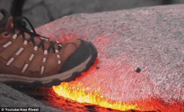
https://www.youtube.com/watch?v=YTiWetiJVN8
Stepping on lava
Top of Page Bottom of Page PermalinkFull Name: |-|/-\|_|_
mesmerizing
mesmerizing
https://www.youtube.com/watch?v=HtihmXFWqGo
Top of Page Bottom of Page PermalinkFull Name: Druba
(No subject)
Top of Page Bottom of Page PermalinkFull Name: Def. High
Lava reaches Puna geothermal
Lava reaches Puna geothermal plant.
www.hawaiinewsnow.com/.../lava-reaches-site-of-puna-geothermal-plant-no-......
7 hours ago - Puna Geothermal Venture officials just confirmed lava has reached a portion of the 40 acres of their operational plant site. .
The irony is palpable.
Top of Page Bottom of Page PermalinkFull Name: MarkD
Bad link.
Bad link.
Top of Page Bottom of Page PermalinkFull Name: Pipe Slingin'
check this out
check this out
https://www.youtube.com/watch?v=UQlmNzw-yYo&t=205s
Top of Page Bottom of Page PermalinkFull Name: Def. High
Oops.
Oops.
Top of Page Bottom of Page PermalinkFull Name: Def. High
http://www.thinkgeoenergy.com
http://www.thinkgeoenergy.com/lava-creeps-onto-the-site-of-the-puna-geot...
This one should work.
Top of Page Bottom of Page PermalinkFull Name: Druba
Here's an article from last
Here's an article from last week on the power plant;
https://www.timesofisrael.com/israeli-owned-geothermal-plant-in-hawaii-u...
and a recent photo...
Top of Page Bottom of Page PermalinkFull Name: Druba
(No subject)
Top of Page Bottom of Page PermalinkFull Name: Druba
(No subject)
Top of Page Bottom of Page PermalinkFull Name: Druba
(No subject)
Top of Page Bottom of Page PermalinkFull Name: MarkD
Just fucking WOW!
Just fucking WOW!
Top of Page Bottom of Page PermalinkFull Name: St. Mark
Noodler doing outstanding
Noodler doing outstanding work in this thread. Thanks, man; this is my go-to for Kilauea updates.
Top of Page Bottom of Page PermalinkFull Name: Druba
For a quick aside, here's
For a quick aside, here's "burning down the house" from the Hult Center last night (riveting show)
https://www.youtube.com/watch?v=gtNsQhY1Bls
Top of Page Bottom of Page PermalinkFull Name: Druba
The great pacific northwest
The great pacific northwest is helping our close family of Hawaii during this crisis, kudos to all the do-gooders out there!
http://nbc16.com/news/local/red-cross-responders-from-eugene-other-orego...
Top of Page Bottom of Page PermalinkFull Name: Druba
And the tearful part of
And the tearful part of burning down the house
Top of Page Bottom of Page PermalinkFull Name: Druba
(No subject)
Top of Page Bottom of Page PermalinkFull Name: Druba
Ryan Finlay
Ryan Finlay
Wednesday Morning May 30th 6am HST
In the middle of the night, the lava flow from fissure almost doubled in speed from 412 feet/per hour to 718 feet/ per hour as it traveled along Highway 132 and triggered first, a mandatory evacuation of Noni Farms Road area and Hale Kamahina road.
Following that, an evacuation warning was sent out at 1:30 am HST for Kapoho, Kapoho Beach Lots and Vacationland.
If nothing changes, lava could cross Highway 137/beach road today sometime.
At 3am from USGS: “F8 flow has left hwy 132 in the vicinity of Noni Farms road and is following a steepest line of descent that would take it to Four Corners. Recent advance rates are about 600 feet/hour.”
Update: as of 6:30am HST nobody is allowed back in past four corners from beach road. They said that may change, but right now that's what they are saying.
Fissure 8 does not appear to have let up this morning much at all so we can assume that it’s continuing to supply a large amount of lava to this flow.
Top of Page Bottom of Page PermalinkFull Name: |-|/-\|_|_
https://www.youtube.com/watch
https://www.youtube.com/watch?v=_hyE2NO7HnU
Top of Page Bottom of Page PermalinkFull Name: Druba
(No subject)
Top of Page Bottom of Page PermalinkFull Name: Druba
(No subject)
Top of Page Bottom of Page PermalinkFull Name: Druba
(No subject)
Top of Page Bottom of Page PermalinkFull Name: Druba
(No subject)
Top of Page Bottom of Page PermalinkFull Name: Philzone Refugee
Great photos Noodler!
Great photos Noodler!
obligatory Van Halen link:
https://m.youtube.com/watch?v=OCwigPhpiXs
Van Halen: Eruption/You Really Got Me
Top of Page Bottom of Page PermalinkFull Name: |-|/-\|_|_
BOC: The Red And The Black
BOC: The Red And The Black
https://www.youtube.com/watch?v=zIawk-9PApw
Top of Page Bottom of Page PermalinkFull Name: Druba
sorry, couldn't resist...
sorry, couldn't resist...
https://www.youtube.com/watch?v=cbzIVR1OaAY
Top of Page Bottom of Page PermalinkFull Name: Alias
B-52's, with very appropriate
B-52's, with very appropriate video
https://www.youtube.com/watch?v=JtlIaINtf_A
We rented a house in Kapoho Beach Lots so have been eyeballing this greatly and I have familiarized myself with all the relevant geographic points. Crazy ass shit. Bummed we won't get to stay there but Waipio Valley or bust!
Top of Page Bottom of Page PermalinkFull Name: Druba
Top of Page Bottom of Page PermalinkFull Name: Druba
Top of Page Bottom of Page PermalinkFull Name: Druba
(No subject)
Top of Page Bottom of Page PermalinkFull Name: Druba
(No subject)
Top of Page Bottom of Page PermalinkFull Name: _________
Amazing Images !
Amazing Images !
Top of Page Bottom of Page PermalinkFull Name: |-|/-\|_|_
That's too bad Alias, hope y
That's too bad Alias, hope y'all got the deposit back. I read about one B&B that had to issue $25K in refunds on top of losing their place.
And from that latest lava map, it looks like the place we stayed in Kapoho is either gone or at the very least out of commission for a looong time.
Hope those folks land on their feet.
Top of Page Bottom of Page PermalinkFull Name: Alias
We will, unless it stops
We will, unless it stops immediately and everything gets fixed up, in which case I would be happy to stay there. It's a sweet pad, I wish the owners and everyone else the best. But we'll have fun on Hamakua Coast. Did not have time to do all the things we wanted, so we had a Plan B anyway.
Top of Page Bottom of Page PermalinkFull Name: |-|/-\|_|_
And you just may be one of
And you just may be one of the lucky ones who gets to see a lava fountain...
Top of Page Bottom of Page PermalinkFull Name: Druba
(No subject)
Top of Page Bottom of Page PermalinkFull Name: Druba
Top of Page Bottom of Page PermalinkFull Name: Druba
(No subject)
Top of Page Bottom of Page PermalinkFull Name: Druba
(No subject)
Top of Page Bottom of Page PermalinkFull Name: Druba
(No subject)
Top of Page Bottom of Page PermalinkFull Name: Druba
(No subject)
Top of Page Bottom of Page PermalinkFull Name: Druba
(No subject)
Top of Page Bottom of Page PermalinkFull Name: Druba
(No subject)
Top of Page Bottom of Page PermalinkFull Name: Druba
(No subject)
Top of Page Bottom of Page PermalinkFull Name: Druba
Picture was taken by Kylesan
Picture was taken by Kylesan Moore Thunder who is Fishing out side Kapoho right now.
Top of Page Bottom of Page PermalinkFull Name: Druba
(No subject)
Top of Page Bottom of Page PermalinkFull Name: Druba
Ikaika Marzo
Ikaika Marzo
Top of Page Bottom of Page PermalinkFull Name: Druba
Pu'uhonua o Puna
Pu'uhonua o Puna
Top of Page Bottom of Page PermalinkFull Name: _________
Quick Question - Is Lava
Quick Question - Is Lava Fairly Light Once It Has Dried Out ?
Top of Page Bottom of Page PermalinkFull Name: _________
Noodler -- Happy Kids Make Me
Noodler -- Happy Kids Make Me Happy
Top of Page Bottom of Page PermalinkFull Name: Druba
They're serving food to
They're serving food to displaced families at the shelter.
Depends on the type of lava, and may variables... cinder cones / pumice, have lots of air, can be amazingly light. Otherwise, this is mostly basalt, which is relatively low in silicon, basic, and I suppose could be considered heavy.
Top of Page Bottom of Page PermalinkFull Name: Druba
(No subject)
Top of Page Bottom of Page PermalinkFull Name: Druba
(No subject)
Top of Page Bottom of Page PermalinkFull Name: Druba
(No subject)
Top of Page Bottom of Page PermalinkFull Name: Druba
(No subject)
Top of Page Bottom of Page PermalinkFull Name: treat island
Man, some really great photos
Man, some really great photos! Thanks.
Top of Page Bottom of Page PermalinkFull Name: Druba
Rescued animals, including
Rescued animals, including Ginger the lava cat (that amazing cat pic above), with Axel Kratel
Top of Page Bottom of Page PermalinkFull Name: Druba
Ginger, safe and sound (well,
Ginger, safe and sound (well, a little freaked out)
Top of Page Bottom of Page PermalinkFull Name: Druba
(No subject)
Top of Page Bottom of Page PermalinkFull Name: Druba
(No subject)
Top of Page Bottom of Page PermalinkFull Name: Druba
"Rescue me"
"Rescue me"
Top of Page Bottom of Page PermalinkFull Name: Druba
"Help on the way"
"Help on the way"
Top of Page Bottom of Page PermalinkFull Name: Druba
(No subject)
Top of Page Bottom of Page PermalinkFull Name: Druba
(No subject)
Top of Page Bottom of Page PermalinkFull Name: Druba
Top of Page Bottom of Page PermalinkFull Name: Druba
(No subject)
Top of Page Bottom of Page PermalinkFull Name: Druba
(No subject)
Top of Page Bottom of Page PermalinkFull Name: Druba
(No subject)
Top of Page Bottom of Page PermalinkFull Name: Druba
(No subject)
Top of Page Bottom of Page PermalinkFull Name: MarkD
Wow! The devastation. And it
Wow! The devastation. And it looks like my favorite snorkel place is about to go away. Gonna hurt this area for a very long time.
Thanks for all your efforts Noodler. It is nice to get all the coverage we need right here. Viva La Zone!
Top of Page Bottom of Page PermalinkFull Name: Druba
(No subject)
Top of Page Bottom of Page PermalinkFull Name: Druba
Top of Page Bottom of Page PermalinkFull Name: Druba
(No subject)
Top of Page Bottom of Page PermalinkFull Name: Druba
(No subject)
Top of Page Bottom of Page PermalinkFull Name: Druba
(No subject)
Top of Page Bottom of Page PermalinkFull Name: Druba
(No subject)
Top of Page Bottom of Page PermalinkFull Name: Druba
(No subject)
Top of Page Bottom of Page PermalinkFull Name: Druba
(No subject)
Top of Page Bottom of Page PermalinkFull Name: Druba
(No subject)
Top of Page Bottom of Page PermalinkFull Name: _________
Had to Post this Song__ The
Had to Post this Song__ The Sea Refuses No River pete townshend ___ Even Lava.
https://www.youtube.com/watch?v=vOFyO6IqYk0
Top of Page Bottom of Page PermalinkFull Name: Druba
(No subject)
Top of Page Bottom of Page PermalinkFull Name: Druba
(No subject)
Top of Page Bottom of Page PermalinkFull Name: Druba
(No subject)
Top of Page Bottom of Page PermalinkFull Name: Zzzzzz
3.9 earthquake today.
3.9 earthquake today. Warnings all the way here in Kauai
Top of Page Bottom of Page PermalinkFull Name: Zzzzzz
oops. Make that a 5.5
oops. Make that a 5.5
Top of Page Bottom of Page PermalinkFull Name: Philzone Refugee
Smoke on the water,
Smoke on the water,
Fire in the skies
Top of Page Bottom of Page PermalinkFull Name: Alias
It is apparently now flowing
It is apparently now flowing into Kapoho Bay
Top of Page Bottom of Page PermalinkFull Name: |-|/-\|_|_
well, that should clear up
well, that should clear up the bacteria issue in the tide pools...
Top of Page Bottom of Page PermalinkFull Name: Druba
(No subject)
Top of Page Bottom of Page PermalinkFull Name: Druba
(No subject)
Top of Page Bottom of Page PermalinkFull Name: Druba
(No subject)
Top of Page Bottom of Page PermalinkFull Name: Druba
(No subject)
Top of Page Bottom of Page PermalinkFull Name: Druba
(No subject)
Top of Page Bottom of Page PermalinkFull Name: Druba
Top of Page Bottom of Page PermalinkFull Name: Druba
(No subject)
Top of Page Bottom of Page PermalinkFull Name: Druba
Top of Page Bottom of Page PermalinkFull Name: Alias
Amazing that it is steaming
Amazing that it is steaming out there in the middle of the bay.
Top of Page Bottom of Page PermalinkFull Name: Druba
Meanwhile in Guatemala (the
Meanwhile in Guatemala (the geysers in Yellowstone have been acting up too)
Top of Page Bottom of Page PermalinkFull Name: Druba
(No subject)
Top of Page Bottom of Page PermalinkFull Name: Druba
(No subject)
Top of Page Bottom of Page PermalinkFull Name: MarkD
https://vimeo.com/273427394
https://vimeo.com/273427394
I am heartbroken. The coral in those tide pools. The lava is entering the water at the same place we often did.
Lots of A Class Zoners have snorkeled there.
Sad.
Top of Page Bottom of Page PermalinkFull Name: Def. High
Mom's not happy.
Mom's not happy.
Top of Page Bottom of Page PermalinkFull Name: Alias
Re post, not sure what
Re post, not sure what happened but:
Mark, I believe that the area shown in those photos where the lava has entered the water is Kapoho Bay, where the popular Champagne Ponds are. The "Kapoho Tidepool" area is just a little to the south, on the other side of a little point. Who knows, by noon that area might be destroyed too, but not quite yet. This map shows the area.....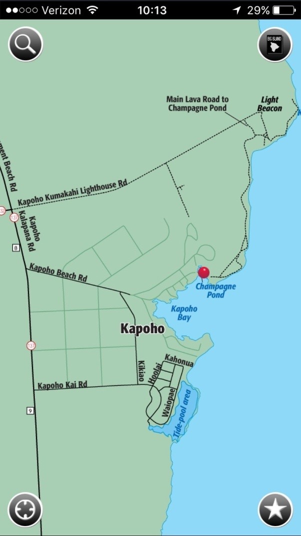
Top of Page Bottom of Page PermalinkFull Name: Alias
Judit, FYI if you are out
Judit, FYI if you are out there, third time this week I completed a post and went back later and it was gone. Should I take this personally? :)
Top of Page Bottom of Page PermalinkFull Name: Alias
Well, now that Hawaii is
Well, now that Hawaii is awake, one paper is reporting that Vacationland, where the tidepools are, is now inundated, which would have been an overnight development. Not seeing that elsewhere yet, but seemed like that might happen. Wow.
Top of Page Bottom of Page PermalinkFull Name: Druba
Kīlauea Message Tue, 05 Jun
Kīlauea Message Tue, 05 Jun 2018 07:02:08 HST: HVO Overflight at 6:30 AM HST confirms lava extends 0.7 miles into Kapoho Bay; most of Vacationland and all but northern edge of Kapoho Beach Lots inundated; Fissure 8 fountain to 150' but lava channel still full.
Top of Page Bottom of Page PermalinkFull Name: Druba
(No subject)
Top of Page Bottom of Page PermalinkFull Name: Druba
(No subject)
Top of Page Bottom of Page PermalinkFull Name: treat island
Judit, FYI if you are out
No, I don't think you should take it personally, but would watch your back for lava flow (black on black) :)
In the real world, I don't know how that would happen if you hadn't deleted it once it had been posted. Let us know if it happens again, note circumstances.
Top of Page Bottom of Page PermalinkFull Name: MarkD
Thanks for the clarification,
Thanks for the clarification, Alias. Glad (for the moment) that I was mistaken. I think Vacation land was north of the bay, so the tidepools may be OK for now. Hoping.
Top of Page Bottom of Page PermalinkFull Name: Alias
Unfortunately it seems like
Unfortunately it seems like the moment is passed, Vacationland mostly destroyed, assuming that means tidepools inundated as well. :(
Top of Page Bottom of Page PermalinkFull Name: Druba
yep, the bay is now a point..
yep, the bay is now a point...
Top of Page Bottom of Page PermalinkFull Name: Druba
(No subject)
Top of Page Bottom of Page PermalinkFull Name: Alias
Check out the house we rented
Check out the house we rented, bottom of photo. A real lesson on the concept of impermanence. That smoking black rock was a beautiful bay on Saturday. :(
Top of Page Bottom of Page PermalinkFull Name: Druba
(No subject)
Top of Page Bottom of Page PermalinkFull Name: Druba
Top of Page Bottom of Page PermalinkFull Name: Druba
(No subject)
Top of Page Bottom of Page PermalinkFull Name: Druba
(No subject)
Top of Page Bottom of Page PermalinkFull Name: Druba
Top of Page Bottom of Page PermalinkFull Name: Druba
(No subject)
Top of Page Bottom of Page PermalinkFull Name: Druba
(No subject)
Top of Page Bottom of Page PermalinkFull Name: DNB - Best band & fans in the land!
heartbreaking to know that
heartbreaking to know that the iconic Kapoho Tidepools have been overrun by the lava flows...
really glad I snorkeled there on 4 separate occasions... best snorkeling I've ever experienced in terms of the diversity of fish and corals... and oh man, the variety and intensity of the COLORS was unmatched
at least I have the memories, and some underwater photos
Top of Page Bottom of Page PermalinkFull Name: Druba
(No subject)
Top of Page Bottom of Page PermalinkFull Name: Druba
Pele tears / hair
Pele tears / hair (Reticulite)
Top of Page Bottom of Page PermalinkFull Name: Druba
(No subject)
Top of Page Bottom of Page PermalinkFull Name: Druba
(No subject)
Top of Page Bottom of Page PermalinkFull Name: Druba
(No subject)
Top of Page Bottom of Page PermalinkFull Name: Druba
(No subject)
Top of Page Bottom of Page PermalinkFull Name: |-|/-\|_|_
lava groot! (5:42pm post)
lava groot! (5:42pm post)
Top of Page Bottom of Page PermalinkFull Name: jazfish
Last image looks like a young
Edit dude has a Gallegher moustache
Top of Page Bottom of Page PermalinkFull Name: Druba
(No subject)
Top of Page Bottom of Page PermalinkFull Name: Druba
(No subject)
Top of Page Bottom of Page PermalinkFull Name: Druba
(No subject)
Top of Page Bottom of Page PermalinkFull Name: Druba
(No subject)
Top of Page Bottom of Page PermalinkFull Name: Druba
(No subject)
Top of Page Bottom of Page PermalinkFull Name: Druba
(No subject)
Top of Page Bottom of Page PermalinkFull Name: Druba
(No subject)
Top of Page Bottom of Page PermalinkFull Name: Druba
(No subject)
Top of Page Bottom of Page PermalinkFull Name: MarkD
Fucking WOW!
Fucking WOW!