>>>Pretty sure they will shut down skiing in that weather.
Skied at Stowe in that kind of cold. They gave you big blankets for the chair lift. Got frost bite on my ear lobes the only exposed skin. Now I get angry when my morning walk with dog is colder than 40 degrees.
Currently the models have it getting interesting Weds on, as most of the models now agree on a decent arctic outbreak, with lows 15-20 and highs in the 30's. Where they disagree is on how much moisture we get, and where. Some models keep us dry, others dump the snow... it's hard to say this far out, but the models are usually over zealous with change... I picture something similar to what happened last time, with the question being is there more moisture, and how long will the cold last this time.
Todays Portland NWS meme (snow lovers go meh)
And the models vary a bit too
to heavy snow forecast;
Hard to say this far out, except it'll get cold, just a matter of how wet
Thanks. As usual, we know some things and don't know some others. Last time it got very cold here (Dec? January?) my gas heater/stove wasn't working. It's working now.
It's easier to model weather coming from the SW... when arctic air comes down from the north / NW around here, a hundred miles can be difference between dry and dumping snow, vorticity centers can be a real annoyance that way.
Big whorls have little whorls
That feed on their velocity,
And little whorls have lesser whorls
And so on to viscosity.
– Lewis F. Richardson, 1920
Sunday afternoons PDX NWS discussion was pretty decent, and goes into great detail for you weather nerds;
.SHORT TERM /THROUGH MONDAY NIGHT/...
Key Messages...
* High probability and confidence for moderate to heavy snow
along the Cascades.
* Gusty westerly winds starting on Monday afternoon through
Tuesday.
* Much below normal temperatures on Thursday morning through
Saturday morning.
Weak high pressure lingers through Monday but will be short
lived as a strengthening low pressure system moves southward
along the Washington and Oregon coast from the Alaska Panhandle
on Tuesday. This system will be the main weather maker over the
next several days. Monday's weather remains nearly unchanged
with scattered showers throughout the forecast area with little
to no accumulation expected. As the upper level trough and low
sink southward though...that is another story.
As the front traverses the Pacific Northwest late Monday, it
will usher in ample precipitation and westerly flow to the
Pacific Northwest, making it to northwest Oregon by Tuesday.
Colder air from the Gulf of Alaska will filter into the region
with temperatures at 850 mb (5000 ft). At those levels,
temperatures will drop from +4C to -4C within 12 hours. Surface
temperatures will remain unchanged initially. Along the cold
frontal boundary, convection will increase and vertical motion
will be enhanced by the temperature differences. Have maintained
around a 20% chance of thunderstorms along the coast and over
the waters from early Tuesday morning through the end of the
frontal passage on Wednesday morning. In reality, these chances
are lower and if thunderstorms do manifest, they will spotty
with isolated strikes.
The big headline in the short term is snow and wind. Let's start
with wind. Aloft, the low is dropping southward and the jet is
becoming more zonal. The first jet streak will move over the
forecast area on late Monday and early Tuesday (enhancing that
convection previously mentioned) with wind speeds of up to 140
kt at 500 mb (30,000 ft). Isobars and isoheights will intensify
through the afternoon which will correlate with an increasing
pressure gradient at the surface. Wind speeds will increase from
the west with gusts up to 30-35 mph in the Willamette Valley,
30-45 mph through the Columbia River Gorge above 500 ft, and up
to 70 mph along the Cascades above 6000 ft. Highest wind speeds
will be along the volcanos and the ridges, but especially the
peak of Mt. Hood.
In regards to snow, there will be variable amounts throughout
the forecast area so here is a quick summary started from
highest confidence to the lowest confidence. Up first is Cascade
snow. The vertical profile of the environment supports a dry
snow along the mountains with accumulations possible into the
'feets'. Decided to keep around a 10-12:1 snow ratio there. There
will be some orographic lift which will enhance the already
strengthening frontal boundary. Have issued a Winter Storm Watch
for all of the Cascades, foothills, and also includes the Coast
Range. With the gusty winds, could experience blowing snow
conditions with reduced visibility. The passes may not experience
visibility reduced conditions. Moderate confidence lies with
the Coast Range snow amounts. These snow amounts will depend on
the amount of cold air, however the depth once again is
favorable. Will see up to 10 inches of snow along the range
north of OR Hwy 20 above 1500 ft. Now low elevation snow once
again will be variable. The low pressure system will move right
over the forecast area through Tuesday into Wednesday. As it
does so, the stratiform precipitation will become more showery
as deformation bands form. These deformation zones will greatly
impact the location and intensity of QPF amounts. There is a
strong chance that this precipitation will manifest similar to
our last winter system with very spotty locations of snow and
other receiving just rain or just a dusting. Accumulations too
will vary. There is around a 50% chance that the area around
Portland will see any measurable snow (more than a trace), but
less than a 30% chance that areas will see more than an inch.
That means that the probability of seeing less than an inch of
snow is higher...if the area sees snow at all. This is just one
example, but much of the Willamette Valley will follow a
similar trend. At this point, cannot say with high or even
moderate confidence that low elevations will see snow, but
cannot rule it out either.
Precipitation will persist through Wednesday morning before
becoming showery once again in the afternoon. The majority of
the impactful snow/rain will end late Wednesday morning.
.LONG TERM...(WEDNESDAY NIGHT THROUGH SATURDAY)...
Key Messages...
* Very cold temperatures Thursday through Friday.
* Cooler temperatures may linger through Saturday.
* Low confidence wintery mix precipitation on Saturday.
As the low shifts southward through Wednesday into Thursday,
precipitation will ease and winds will become easterly. It is
this easterly wind component that will be the determining factor
for snow development in the low elevations. The difficulty is
that the precipitation is letting up at a similar time...hence
the low confidence. However, with those easterly winds,
preparing for much colder temperatures - especially overnight.
As the low exits, a weak inverted trough will form causing skies
to begin to clear and winds to eventually let up. Ensemble
guidance is showing quite the spread of temperature outcomes for
Thursday morning through at least Friday. Looking at
temperatures aloft to get the general feel, 850 mb temperatures
will fall to around -14 to -17 degrees C which will slowly
filter westward. While values will not be nearly as cold here
due to the blocking of the Cascades, will definitely see some of
the coldest temperatures thus far this winter. As previously
stated though, ensemble model guidance is struggling a bit in
the long term to get a handle on the possible outcomes. For
Salem, the 10th percentile is around 20F, while the 90th
percentile is 29F on Thursday. Friday's 10th percentile is 13F
while the 90th is 23F. So as you can see quite the spread. This
trend is similar throughout the forecast area.
The next feature is yet another low dropping down from the north
on Saturday. Models are not handling this well as of yet, both
in the intensity and in the track. Looking at the 7 day cluster
analysis, even one of the clusters is showing a weak ridging
pattern. Because of this, cannot truly come to a consensus on
what will happen weather wise. Deterministic models appear to be
all around the board in the timing of precipitation, the
weakening of the easterly winds, etc. Will say that we cannot
rule out another winter weather event on Saturday into Sunday
though. Will continue to monitor future model runs as time
progresses.
Seattle caught a break. Just some light flurries with no accumulation. It will be a little on the cold side the next couple of days. Currently it's 28, but with clear sunshine forecast this afternoon, we should get up to 36. No ice to navigate is a plus. Should be a nice day to get out and about if you're dressed for the weather.
...GALE WATCH IN EFFECT FROM LATE TONIGHT THROUGH SATURDAY
MORNING...
TODAY
Wind west 10 to 15 knots with gusts to 20 knots. Wind
waves around 4 feet. Swell west 3 to 6 feet at 10 seconds.
Showers.
TONIGHT
Wind southwest 10 to 15 knots...becoming south 15 to
20 knots after midnight. Wind waves around 4 feet. Swell
southwest 4 to 5 feet at 9 seconds. Showers likely in the
evening, then rain likely after midnight.
FRIDAY
Wind south 15 to 25 knots with gusts to 30 knots...
becoming 25 to 30 knots with gusts to 40 knots in the afternoon.
Combined seas 7 to 9 feet dominant period 9 seconds...building to
12 to 14 feet dominant period 9 seconds in the afternoon. A
chance of rain in the morning, then rain likely in the afternoon.
FRIDAY NIGHT
Wind south 25 to 30 knots...becoming 20 to
30 knots after midnight. Gusts to 35 knots. Combined seas 13 to
17 feet dominant period 10 seconds. Rain.
SATURDAY
Wind southwest 10 to 20 knots with gusts to
25 knots...becoming 10 to 15 knots in the afternoon. Wind waves
around 4 feet. Mixed swell west 3 to 6 feet at 10 seconds and
south 7 to 10 feet at 8 seconds. Rain in the morning, then
showers in the afternoon.
SATURDAY NIGHT
Wind west 10 to 15 knots with gusts to
20 knots. Wind waves around 3 feet. Mixed swell west 3 to 4 feet
and south 3 to 6 feet. Showers likely, mainly in the evening.
Yeah, it's 32 and snowy every morning. Only takes a couple of inches of icy snow to keep us stuck up on this hill. Then it melts enough in the PM to let us get to town.
Good thing we're retired - otherwise we'd be fired.
For elevations above 5000 to 6000 feet, 2 to 4 feet is possible north of Interstate 80 and 4 to 8 feet is possible to the south. The heaviest snow will be above 7000 feet, with even higher totals possible above 8000 feet. Strong winds will accompany this storm Thursday night and Friday. Southerly gusts of 45 to 55 mph are likely across the Valley
And then we get to do it all again
.EXTENDED DISCUSSION (Monday THROUGH Thursday)... forecast indicates 1-2+" across the Valley, with 2-5" over the foothills and mountains. Heavy snow is also possible at the higher mountain elevations. Snow levels for the extended forecast period start off between 5000 to 7000 feet Monday, lowering to 4000-6000 feet Tuesday.
It's a sunny 70 here in LA today and there is growing concern of forecast rain, melting snow, and big floods at/around lower elevation mountain areas and foothills....which is probably a larger scale of 'normal'.
Differences also exist with QPF, but highest amounts appear to be over the Sierra Nevada, where an additional 3 to 8 feet of snow looks likely by midweek. Models suggest a brief break Thursday under short wave ridging, then more systems could impact the area towards the end of the week.
Top of Page Bottom of Page Permalink
We are headed up to Sugarloaf
We are headed up to Sugarloaf mountain in Maine for a music fest this weekend (Fire on the Mtn).
The temps will be 25 below zero, wind chills breaking 50 below!
Pretty sure they will shut down skiing in that weather.
Portland is gonna be coldest since Jan 1971.
Top of Page Bottom of Page Permalink
Please her with a tweezer.
Please her with a tweezer.
Top of Page Bottom of Page Permalink
A frigid 46 here right now.
A frigid 46 here right now. I don't know how you northerners do it.
Top of Page Bottom of Page Permalink
What Zang said
What Zang said
Top of Page Bottom of Page Permalink
Drugs, Booze and Phil Lesh
Drugs, Booze and Phil Lesh
Top of Page Bottom of Page Permalink
-15 Below here now in upstate
-15 Below here now in upstate ny ......brrrrr
Top of Page Bottom of Page Permalink
>>>Pretty sure they will shut
>>>Pretty sure they will shut down skiing in that weather.
Skied at Stowe in that kind of cold. They gave you big blankets for the chair lift. Got frost bite on my ear lobes the only exposed skin. Now I get angry when my morning walk with dog is colder than 40 degrees.
Top of Page Bottom of Page Permalink
USA hit -108* with wind chill
USA hit -108* with wind chill. Hot damn.
Top of Page Bottom of Page Permalink
so disappointed
so disappointed
(((uncle ebenezer)))
Top of Page Bottom of Page Permalink
Sorta a Kasvat show on
Sorta a Kasvat show on Halloween for sho'
Top of Page Bottom of Page Permalink
New Banksy artwork appears
New Banksy artwork appears for Valentine's Day:
https://www.npr.org/2023/02/14/1156849741/banksy-valentines-day-violence...
Top of Page Bottom of Page Permalink
Noodler, could you take us
Noodler, could you take us through the coming week's weather in the Willamette Valley? Not so cold, cold, snow, fucking freezing lows...
Top of Page Bottom of Page Permalink
If it is NW Oregon of which
Ah, the great NW
Currently the models have it getting interesting Weds on, as most of the models now agree on a decent arctic outbreak, with lows 15-20 and highs in the 30's. Where they disagree is on how much moisture we get, and where. Some models keep us dry, others dump the snow... it's hard to say this far out, but the models are usually over zealous with change... I picture something similar to what happened last time, with the question being is there more moisture, and how long will the cold last this time.
Todays Portland NWS meme (snow lovers go meh)
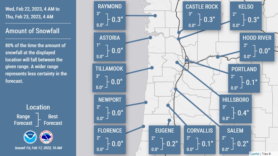
And the models vary a bit too
to heavy snow forecast;
Hard to say this far out, except it'll get cold, just a matter of how wet
Top of Page Bottom of Page Permalink
The general flow in the PNW
The general flow in the PNW will be from the NW over the next week.
Top of Page Bottom of Page Permalink
Thanks. As usual, we know
Thanks. As usual, we know some things and don't know some others. Last time it got very cold here (Dec? January?) my gas heater/stove wasn't working. It's working now.
Top of Page Bottom of Page Permalink
It's easier to model weather
It's easier to model weather coming from the SW... when arctic air comes down from the north / NW around here, a hundred miles can be difference between dry and dumping snow, vorticity centers can be a real annoyance that way.
Big whorls have little whorls
That feed on their velocity,
And little whorls have lesser whorls
And so on to viscosity.
– Lewis F. Richardson, 1920
Top of Page Bottom of Page Permalink
Western Oregon updated
Western Oregon updated forecast;
Sunday afternoons PDX NWS discussion was pretty decent, and goes into great detail for you weather nerds;
.SHORT TERM /THROUGH MONDAY NIGHT/...
Key Messages...
* High probability and confidence for moderate to heavy snow
along the Cascades.
* Gusty westerly winds starting on Monday afternoon through
Tuesday.
* Much below normal temperatures on Thursday morning through
Saturday morning.
Weak high pressure lingers through Monday but will be short
lived as a strengthening low pressure system moves southward
along the Washington and Oregon coast from the Alaska Panhandle
on Tuesday. This system will be the main weather maker over the
next several days. Monday's weather remains nearly unchanged
with scattered showers throughout the forecast area with little
to no accumulation expected. As the upper level trough and low
sink southward though...that is another story.
As the front traverses the Pacific Northwest late Monday, it
will usher in ample precipitation and westerly flow to the
Pacific Northwest, making it to northwest Oregon by Tuesday.
Colder air from the Gulf of Alaska will filter into the region
with temperatures at 850 mb (5000 ft). At those levels,
temperatures will drop from +4C to -4C within 12 hours. Surface
temperatures will remain unchanged initially. Along the cold
frontal boundary, convection will increase and vertical motion
will be enhanced by the temperature differences. Have maintained
around a 20% chance of thunderstorms along the coast and over
the waters from early Tuesday morning through the end of the
frontal passage on Wednesday morning. In reality, these chances
are lower and if thunderstorms do manifest, they will spotty
with isolated strikes.
The big headline in the short term is snow and wind. Let's start
with wind. Aloft, the low is dropping southward and the jet is
becoming more zonal. The first jet streak will move over the
forecast area on late Monday and early Tuesday (enhancing that
convection previously mentioned) with wind speeds of up to 140
kt at 500 mb (30,000 ft). Isobars and isoheights will intensify
through the afternoon which will correlate with an increasing
pressure gradient at the surface. Wind speeds will increase from
the west with gusts up to 30-35 mph in the Willamette Valley,
30-45 mph through the Columbia River Gorge above 500 ft, and up
to 70 mph along the Cascades above 6000 ft. Highest wind speeds
will be along the volcanos and the ridges, but especially the
peak of Mt. Hood.
In regards to snow, there will be variable amounts throughout
the forecast area so here is a quick summary started from
highest confidence to the lowest confidence. Up first is Cascade
snow. The vertical profile of the environment supports a dry
snow along the mountains with accumulations possible into the
'feets'. Decided to keep around a 10-12:1 snow ratio there. There
will be some orographic lift which will enhance the already
strengthening frontal boundary. Have issued a Winter Storm Watch
for all of the Cascades, foothills, and also includes the Coast
Range. With the gusty winds, could experience blowing snow
conditions with reduced visibility. The passes may not experience
visibility reduced conditions. Moderate confidence lies with
the Coast Range snow amounts. These snow amounts will depend on
the amount of cold air, however the depth once again is
favorable. Will see up to 10 inches of snow along the range
north of OR Hwy 20 above 1500 ft. Now low elevation snow once
again will be variable. The low pressure system will move right
over the forecast area through Tuesday into Wednesday. As it
does so, the stratiform precipitation will become more showery
as deformation bands form. These deformation zones will greatly
impact the location and intensity of QPF amounts. There is a
strong chance that this precipitation will manifest similar to
our last winter system with very spotty locations of snow and
other receiving just rain or just a dusting. Accumulations too
will vary. There is around a 50% chance that the area around
Portland will see any measurable snow (more than a trace), but
less than a 30% chance that areas will see more than an inch.
That means that the probability of seeing less than an inch of
snow is higher...if the area sees snow at all. This is just one
example, but much of the Willamette Valley will follow a
similar trend. At this point, cannot say with high or even
moderate confidence that low elevations will see snow, but
cannot rule it out either.
Precipitation will persist through Wednesday morning before
becoming showery once again in the afternoon. The majority of
the impactful snow/rain will end late Wednesday morning.
.LONG TERM...(WEDNESDAY NIGHT THROUGH SATURDAY)...
Key Messages...
* Very cold temperatures Thursday through Friday.
* Cooler temperatures may linger through Saturday.
* Low confidence wintery mix precipitation on Saturday.
As the low shifts southward through Wednesday into Thursday,
precipitation will ease and winds will become easterly. It is
this easterly wind component that will be the determining factor
for snow development in the low elevations. The difficulty is
that the precipitation is letting up at a similar time...hence
the low confidence. However, with those easterly winds,
preparing for much colder temperatures - especially overnight.
As the low exits, a weak inverted trough will form causing skies
to begin to clear and winds to eventually let up. Ensemble
guidance is showing quite the spread of temperature outcomes for
Thursday morning through at least Friday. Looking at
temperatures aloft to get the general feel, 850 mb temperatures
will fall to around -14 to -17 degrees C which will slowly
filter westward. While values will not be nearly as cold here
due to the blocking of the Cascades, will definitely see some of
the coldest temperatures thus far this winter. As previously
stated though, ensemble model guidance is struggling a bit in
the long term to get a handle on the possible outcomes. For
Salem, the 10th percentile is around 20F, while the 90th
percentile is 29F on Thursday. Friday's 10th percentile is 13F
while the 90th is 23F. So as you can see quite the spread. This
trend is similar throughout the forecast area.
The next feature is yet another low dropping down from the north
on Saturday. Models are not handling this well as of yet, both
in the intensity and in the track. Looking at the 7 day cluster
analysis, even one of the clusters is showing a weak ridging
pattern. Because of this, cannot truly come to a consensus on
what will happen weather wise. Deterministic models appear to be
all around the board in the timing of precipitation, the
weakening of the easterly winds, etc. Will say that we cannot
rule out another winter weather event on Saturday into Sunday
though. Will continue to monitor future model runs as time
progresses.
https://www.wrh.noaa.gov/pqr/forecasts.php
Top of Page Bottom of Page Permalink
Well, that prediction of
Well, that prediction of "less than an inch" of snow in Portland turned out to be a wee bit off.
Total surprise blizzard dumping almost 11 inches of snow, which isn't going to start melting until Friday. Town is shut down.
Top of Page Bottom of Page Permalink
We have a blizzard warning in
We have a blizzard warning in SoCal for the next couple of days. I live at 4800'.
Top of Page Bottom of Page Permalink
Wow, that's a lot of snow Ken
Wow, that's a lot of snow Ken, I don't often think that Portland gets that much. Second largest dump evah.
Probably some light accumulation expected here in the Bay Area hills, certainly on Mt. Tam (~2600')
Top of Page Bottom of Page Permalink
Seattle caught a break. Just
Seattle caught a break. Just some light flurries with no accumulation. It will be a little on the cold side the next couple of days. Currently it's 28, but with clear sunshine forecast this afternoon, we should get up to 36. No ice to navigate is a plus. Should be a nice day to get out and about if you're dressed for the weather.
Top of Page Bottom of Page Permalink
...GALE WATCH IN EFFECT FROM
...GALE WATCH IN EFFECT FROM LATE TONIGHT THROUGH SATURDAY
MORNING...
TODAY
Wind west 10 to 15 knots with gusts to 20 knots. Wind
waves around 4 feet. Swell west 3 to 6 feet at 10 seconds.
Showers.
TONIGHT
Wind southwest 10 to 15 knots...becoming south 15 to
20 knots after midnight. Wind waves around 4 feet. Swell
southwest 4 to 5 feet at 9 seconds. Showers likely in the
evening, then rain likely after midnight.
FRIDAY
Wind south 15 to 25 knots with gusts to 30 knots...
becoming 25 to 30 knots with gusts to 40 knots in the afternoon.
Combined seas 7 to 9 feet dominant period 9 seconds...building to
12 to 14 feet dominant period 9 seconds in the afternoon. A
chance of rain in the morning, then rain likely in the afternoon.
FRIDAY NIGHT
Wind south 25 to 30 knots...becoming 20 to
30 knots after midnight. Gusts to 35 knots. Combined seas 13 to
17 feet dominant period 10 seconds. Rain.
SATURDAY
Wind southwest 10 to 20 knots with gusts to
25 knots...becoming 10 to 15 knots in the afternoon. Wind waves
around 4 feet. Mixed swell west 3 to 6 feet at 10 seconds and
south 7 to 10 feet at 8 seconds. Rain in the morning, then
showers in the afternoon.
SATURDAY NIGHT
Wind west 10 to 15 knots with gusts to
20 knots. Wind waves around 3 feet. Mixed swell west 3 to 4 feet
and south 3 to 6 feet. Showers likely, mainly in the evening.
Top of Page Bottom of Page Permalink
Started the snow run last
Started the snow run last night. Much more forecast(100%) today and repeating for the next week.
Top of Page Bottom of Page Permalink
We got more snow last night
We got more snow last night than in at least 50 yrs.
Top of Page Bottom of Page Permalink
What a winter...
Damn.
Top of Page Bottom of Page Permalink
1st major of the year headed
1st major of the year headed straight for CT valley
Oh boy
Top of Page Bottom of Page Permalink
Pretty strange weather… Snow,
Pretty strange weather… Snow, rain, sleet, snow, (break) snow, rain... Not particularly cold, just active.
Top of Page Bottom of Page Permalink
Yeah, it's 32 and snowy every
Yeah, it's 32 and snowy every morning. Only takes a couple of inches of icy snow to keep us stuck up on this hill. Then it melts enough in the PM to let us get to town.
Good thing we're retired - otherwise we'd be fired.
Top of Page Bottom of Page Permalink
Rare western Oregon snow
Rare western Oregon snow flakes breeding in mid air
Top of Page Bottom of Page Permalink
Too hot summers and too cold
Too hot summers and too cold winters suck.
Top of Page Bottom of Page Permalink
Fuggin A California stock up
Fuggin A California stock up and stay safe!
https://www.cnn.com/2023/03/08/weather/california-atmospheric-river-flood-wednesday/index.html
Top of Page Bottom of Page Permalink
We got up to 52 yesterday.
We got up to 52 yesterday. This long, colder than normal Winter is finally losing it's grip.
Top of Page Bottom of Page Permalink
it's the new, new changed
it's the new, new changed climate blues
Top of Page Bottom of Page Permalink
From one extreme to the other
From one extreme to the other.
For elevations above 5000 to 6000 feet, 2 to 4 feet is possible north of Interstate 80 and 4 to 8 feet is possible to the south. The heaviest snow will be above 7000 feet, with even higher totals possible above 8000 feet. Strong winds will accompany this storm Thursday night and Friday. Southerly gusts of 45 to 55 mph are likely across the Valley
And then we get to do it all again
.EXTENDED DISCUSSION (Monday THROUGH Thursday)... forecast indicates 1-2+" across the Valley, with 2-5" over the foothills and mountains. Heavy snow is also possible at the higher mountain elevations. Snow levels for the extended forecast period start off between 5000 to 7000 feet Monday, lowering to 4000-6000 feet Tuesday.
Top of Page Bottom of Page Permalink
It's a sunny 70 here in LA
It's a sunny 70 here in LA today and there is growing concern of forecast rain, melting snow, and big floods at/around lower elevation mountain areas and foothills....which is probably a larger scale of 'normal'.
Top of Page Bottom of Page Permalink
Yeah Sacramento is second
Yeah Sacramento is second behind New Orleans for most likely to suffer catastrophic flooding. Time to listen to some Steve Earl
https://youtu.be/g2iQMW3-268?t=177
Top of Page Bottom of Page Permalink
The Rains Never Cease To End
The Rains Never Cease To End ! We Got Slammed Downpours For Hours Earlier !!
Top of Page Bottom of Page Permalink
It just doesn't stop:
It just doesn't stop:
Differences also exist with QPF, but highest amounts appear to be over the Sierra Nevada, where an additional 3 to 8 feet of snow looks likely by midweek. Models suggest a brief break Thursday under short wave ridging, then more systems could impact the area towards the end of the week.
Top of Page Bottom of Page Permalink
It might still be raining
It might still be raining here when we get on the plane for Hawaii. What a weather shock that will be.
Beautiful here today though. mid 60's. Rain starting up again Sat.
Top of Page Bottom of Page Permalink
landslide and 4 apts red
landslide and 4 apts red tagged here
Top of Page Bottom of Page Permalink
Chairlifts snowed under
Chairlifts snowed under
https://twitter.com/capitalweather/status/1636544327169069057?s=20
Top of Page Bottom of Page Permalink
Holy Shitaki Nino !
Holy shiitake, Nino !
Top of Page Bottom of Page Permalink
And it's Tuesday so why not a
And it's Tuesday so why not a little huricane action for Santa Cruz
Top of Page Bottom of Page Permalink
it hailed here earlier with a
it hailed here earlier with a crispy cold ~~~ rad. springing..
Top of Page Bottom of Page Permalink
Well we used to be able to
Well we used to be able to say I'd rather have earthquakes than tornadoes
https://twitter.com/rergalaxy/status/1638627206049198080?s=20
Top of Page Bottom of Page Permalink