Tropical Storm Ida, soon to be Hurricane Ida
Forums:
Time for more red states to get a visit from a potentially large storm... Hospitals already full of unvaxxed covid patients... no bueno!
- Log in to post comments
Time for more red states to get a visit from a potentially large storm... Hospitals already full of unvaxxed covid patients... no bueno!
Top of Page Bottom of Page PermalinkFull Name: Druba
Top of Page Bottom of Page PermalinkFull Name: Druba
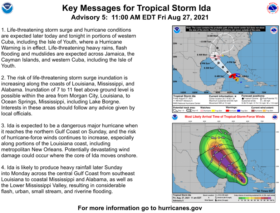
Early forecasts; these could
Early forecasts; these could change as we get closer to landfall
Top of Page Bottom of Page PermalinkFull Name: Druba
Group photo, smile everyone..
Group photo, smile everyone...
Top of Page Bottom of Page PermalinkFull Name: El Nino
In the dystopian climate
In the dystopian climate change novel Water Knife the Gulf Coast refuges who try to escape repeated hurricanes that hit year after year don't do well after the states close their boarders. Meanwhile I have friends staying staying at my house this weekend to escape the smoke in the foothills. Placerville AQI was over 1000 today.
I know someone who has been investing in real estate in Ohio that might be the right move at this point.
Top of Page Bottom of Page PermalinkFull Name: Druba
^
^
Fracking will likely be the end of Ohio's already questionable water supply....
Top of Page Bottom of Page PermalinkFull Name: treat island
OVER 1000? Wow! When it was
OVER 1000? Wow! When it was over 500 here last year I wore an KN95 mask in my old air-leaky house, even to sleep. So nice they can stay with you. The air quality in Grass Valley seems quite a bit better than it has been.
Top of Page Bottom of Page PermalinkFull Name: Rasputin O'Leary
I smiled but I blinked, can
I smiled but I blinked, can you take another one ? Poor Cuba, they've been takin it on the chin lately. The Weather Channel has it heading straight to New Orleans. Not again !!! The severe weather is everywhere these days it seems. Who's got the best weather in this damn country, anybody know ? Who here hasn't had shit happen in a while ? Fires, floods, tornados, earth quakes, hurricanes, we got em all,, and they're all amped up by global warming.
Don't just take me for tryin' to be heavy
Understand, it's time to get ready for the storm
Top of Page Bottom of Page PermalinkFull Name: El Nino
>>>Fracking will likely be
>>>Fracking will likely be the end of Ohio's already questionable water supply...
Didn't know that. I was looking at real estate prices in Minneapolis but they are smoked in from a wild fire this year too. I know some people who are moving to Coos Bay to get away, but I think Brent said it best. You can run but you can't hide.
And to add insult to injury my friends near Placerville can't leave until the power goes back on which PG&E has shut off once again. They have enough solar to run their property and invested in battery back up so they don't need to be on the grid anymore. They had it all set up to go in April and needed to unhook their whole house back up generator in order to get the final approval from PG&E for their batteries. PG&E still hasn't come so the batteries are just sitting their and they can't use them.
Top of Page Bottom of Page PermalinkFull Name: Zzzzzz
>>>>I know someone who has
>>>>I know someone who has been investing in real estate in Ohio that might be the right move at this point.
I've heard Minn and upstate NY will be boom areas due to heat and water demands in the future but it's just a guess.
I wish the people of these southern states well. Let's hope the damage is minimal and they just stay inside for a few days and slow the spread of the virus.
Top of Page Bottom of Page PermalinkFull Name: Druba
One of the models has it
One of the models has it bombing out in the last minute, to become the strongest storm ever... while I really doubt this will be actualized, all the more reason to take it seriously! Be safe Big Easy!
Top of Page Bottom of Page PermalinkFull Name: MarkD
It's cool how so many of us
It's cool how so many of us were giving the PhilZone Salute in that group pic.
Stay safe Jaz and all in the path.
Top of Page Bottom of Page PermalinkFull Name: Druba
Sustained winds of 85mph,
Sustained winds of 85mph, eyewall starting to form, likely to strengthen
Sunrise shot
Top of Page Bottom of Page PermalinkFull Name: Druba
Eye well becoming well
Eye wall becoming more developed, sustained winds of 100mph, should be explosive development as it's about to go over some really warm water (86 degrees)
Top of Page Bottom of Page PermalinkFull Name: Def. High
16 years ago tomorrow,
16 years ago tomorrow, Hurricane Katrina came ashore.
I hope we'll do a better job of rescue and mitigation than we did last time.
Those new storm surge levees and pumping upgrades have never really been put to the test - let's hope they hold up.
Top of Page Bottom of Page PermalinkFull Name: jazfish
Thanks ,Mark. The storm will
Thanks ,Mark. The storm will go east of us.
(((Those in the path.)))
Top of Page Bottom of Page PermalinkFull Name: Ken D.
>>>>Hope we'll do a better
>>>>Hope we'll do a better job of rescue.
Joe Biden doesn't care about black people.
Hang on tight Gulf folks. This is going to be a biggie.
Top of Page Bottom of Page PermalinkFull Name: jazfish
Good luck, Aiq!
Good luck, Aiq! Stay safe ,John.
Top of Page Bottom of Page PermalinkFull Name: Druba
It's been getting larger, but
It's been getting larger, but not stronger today, suppose that's sort of good news (winds 105mph)
Top of Page Bottom of Page PermalinkFull Name: Druba
And since that last post,
And since that last post, lightning is occurring in the eastern eye wall, as the much anticipated explosion occurs, with Ida jumping to a Cat 4 storm now (130mph winds);
I don't think i've ever seen this much lightning in an eye wall before, it's actually unusual (outer bands, sure, but not the eye), no bueno
Top of Page Bottom of Page PermalinkFull Name: Druba
that'd be 146mph
that'd be 146mph
Top of Page Bottom of Page PermalinkFull Name: Druba
Winds picking up in the
Winds picking up in the coastal areas, the buoys feeling it
Top of Page Bottom of Page PermalinkFull Name: Druba
Hurricane Ida Discussion
Hurricane Ida Discussion Number 12
NWS National Hurricane Center Miami FL AL092021 400 AM CDT Sun Aug 29 2021
Ida has undergone some dramatic inner-core structural changes since the previous advisory. The eye between 25,000-45,000 ft has become
circular with a diameter of about 15 nmi now, and at least two eyewall mesocyclones have been noted rotating cyclonically around the eyewall in both radar and high-resolution 1-minute GOES-16 satellite imagery. The result has been rapid strengthening of at least 30 kt during the past 6 hours, along with a pressure drop of more than 15 mb during that same time, with a 6-mb decrease having occurred in the 1-hr period between about 0500-0600 UTC based on Air Force Reserve reconnaissance aircraft eye dropsonde data. The aircraft also measured a maximum 700-mb flight-level wind speed of 133 kt in the northeastern quadrant, along with a peak SFMR surface wind speed of 116 kt. Furthermore, NWS Doppler radar velocity data from Slidell, Louisiana, has recently been measuring velocities of
120-130 kt between 25,000-30,000 ft, which is quite rare, and indicates that Ida is a vertically deep and intense hurricane. Ida was initialized with 115 kt at 0600 UTC, but the 0900 UTC advisory intensity has been increased to 120 kt based on the 133-kt flight-level wind and the improved structure in both radar data and
satellite imagery since the 0609 UTC time of that aircraft observation.
Top of Page Bottom of Page PermalinkFull Name: Druba
(No subject)
Top of Page Bottom of Page PermalinkFull Name: Philzone Refugee
"Hurricane Ida's eyewall
"Hurricane Ida's eyewall basically a15 mile wide F3 tornado."
Al Roker
Keeping New Orleans and all of SE Louisiana in my prayers this morning.
Top of Page Bottom of Page PermalinkFull Name: fishcane
Bourbon street
Bourbon street
https://m.youtube.com/watch?v=1ziciboPx7w
Top of Page Bottom of Page PermalinkFull Name: jazfish
Live YouTube storm reporter
Live YouTube storm reporter cat. In Houma and 40 miles from eye wall coming his way.
https://www.youtube.com/watch?v=Q0k-Qy2v5AA
Not live, updates. My bad.
Top of Page Bottom of Page PermalinkFull Name: jazfish
John Humpfress live
John Humpfress live
https://www.severestudios.com/storm-chasers/john.humphress.html
Top of Page Bottom of Page PermalinkFull Name: Druba
Reed Trimmer, storm chaser
Reed Timmer, storm chaser
https://www.youtube.com/watch?v=LmbE_325rjs
Top of Page Bottom of Page PermalinkFull Name: Strangha
Nat'l Hurricane Center
Nat'l Hurricane Center
https://twitter.com/NHC_Atlantic?ref_src=twsrc%5Etfw%7Ctwcamp%5Etweetemb...
Top of Page Bottom of Page PermalinkFull Name: Rasputin O'Leary
Who besides me is rooting for
Who besides me is rooting for that dumpster to flatten Jim Cantore ? He should be nowheres near that thing.
Top of Page Bottom of Page PermalinkFull Name: Mtndog
Bourbon Street webcam
Bourbon Street webcam
https://www.earthcam.com/usa/louisiana/neworleans/bourbonstreet/?cam=cat...
Top of Page Bottom of Page PermalinkFull Name: Ken D.
It's still a Category 4
It's still a Category 4 hurricane hours after landfall. This is going to be messy.
Top of Page Bottom of Page PermalinkFull Name: Druba
Some observed wind speeds as
Some observed wind speeds as of 4pm PT :
Dulac had sustained winds of 93 mph (135mph gust), South Lafourche airport had sustained winds of 91mph, (122mph gust). Lakefront Airport in New Orleans had sustained winds of 66 mph (84mph gusts), New Orleans International Airport had sustained winds of 62mph, gusts to 81...
Top of Page Bottom of Page PermalinkFull Name: fishcane
Is that enough to knock over
Is that enough to knock over chairs?
Top of Page Bottom of Page PermalinkFull Name: Druba
Meanwhile out west...
Meanwhile out west...
Top of Page Bottom of Page PermalinkFull Name: Rasputin O'Leary
Flipping thru the vinyl
Flipping thru the vinyl tonight -
Top of Page Bottom of Page PermalinkFull Name: jazfish
.
.
https://www.youtube.com/watch?app=desktop&v=MGs2iLoDUYE
Thread needs a song.
Randy Newman Louisiana 1927
Top of Page Bottom of Page PermalinkFull Name: Druba
Ras, a buddy (record shop
Ras, a buddy (record shop owner, total KC / prog nerd), is putting together a band trivia game w/ former employees... I had to send him that album cover, figures there's a good trivia question or 2 in there....
Top of Page Bottom of Page PermalinkFull Name: Zzzzzz
>>>Is that enough to knock
>>>Is that enough to knock over chairs?
Literally tore the roof off the mother sucker
Top of Page Bottom of Page PermalinkFull Name: Rasputin O'Leary
Nice Noodler, I was hoping
Nice Noodler, I was hoping that info would be helpful to someone in filling in some KC mythology.
Top of Page Bottom of Page PermalinkFull Name: krab
Katrina & Ida both make
Katrina & Ida both make landfall 8/29
Grateful Dead Live at Family Dog at the Great Highway on 1969-08-29
Played New Orleans: https://archive.org/details/gd69-08-29.sbd.cotsman.8996.sbeok.shnf/gd69-...
Top of Page Bottom of Page PermalinkFull Name: aiq
Northern gulf coast, tropical
Northern gulf coast, tropical storm effect. Rain, gusts to 35, no damage to casa, no power loss.
Lucky.
Top of Page Bottom of Page PermalinkFull Name: Rasputin O'Leary
< Northern gulf coast
< Northern gulf coast
Soon to be known as the Southern gulf coast. Glad to hear you made out ok